Search Brokers - Rich Johnson
Rich Johnson
Round Spur Ranch
Rich Johnson is a land and rural real estate professional with Round Spur Ranch, listed on Land Broker MLS, the broker-owned co-op for farms, ranches and land for sale. Use the contact form on this page to get in touch about buying or selling rural property.
Contact
Fill in the Form below to send a message to this broker
By submitting, you agree to our privacy policy and terms.
Land for Sale from Rich Johnson
Round Spur Ranch
$850,000
251.5 Acres
Garden Valley, California, 95633
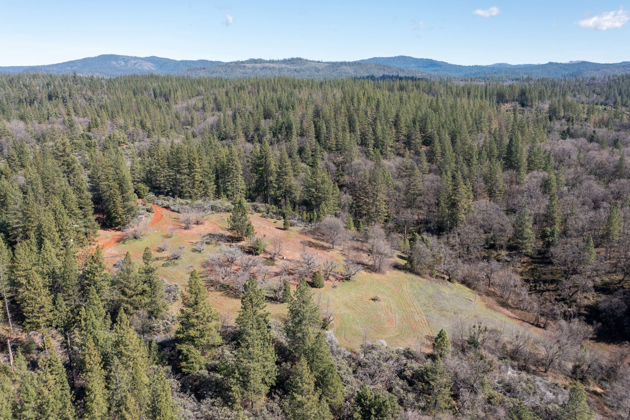
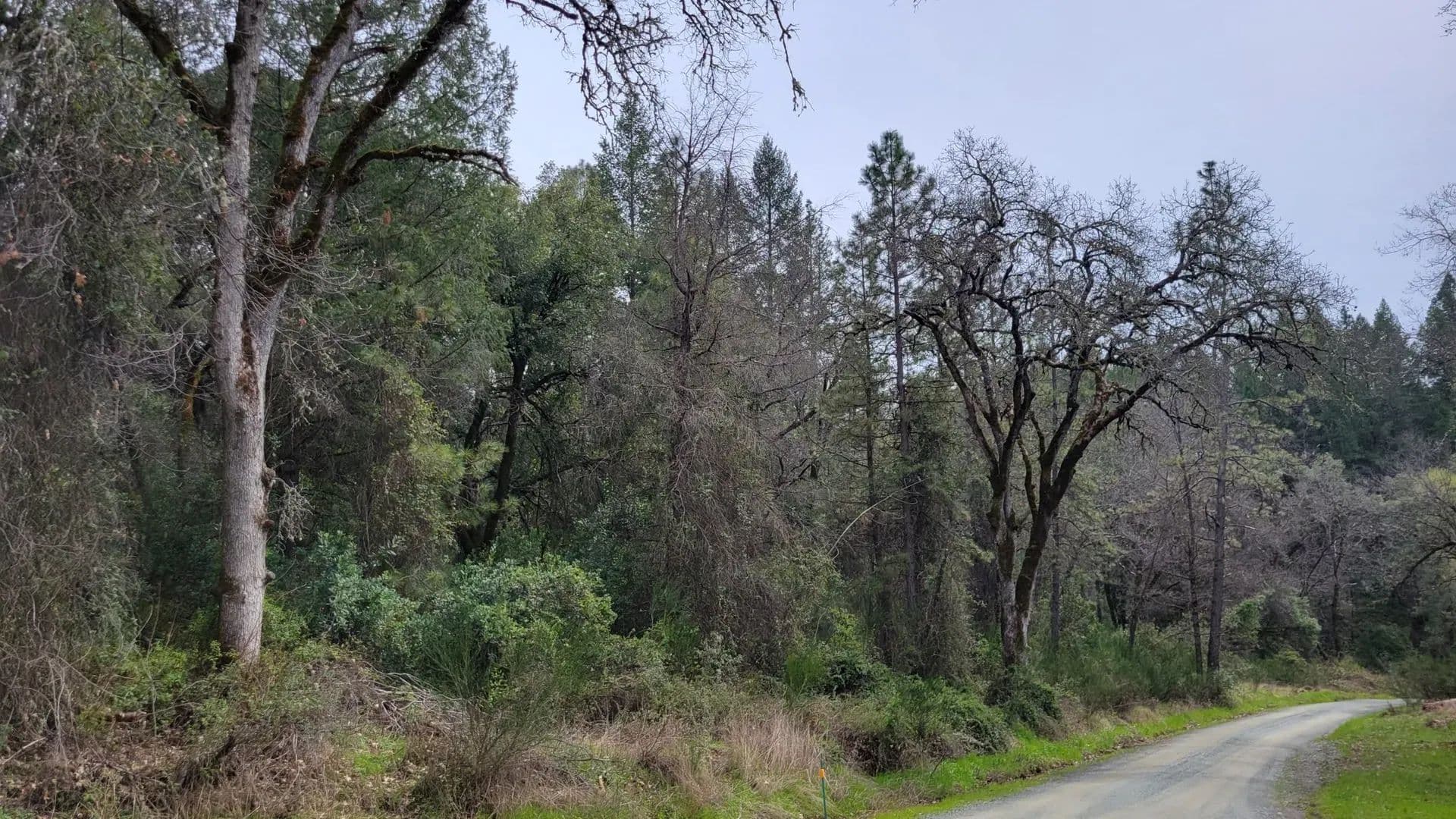
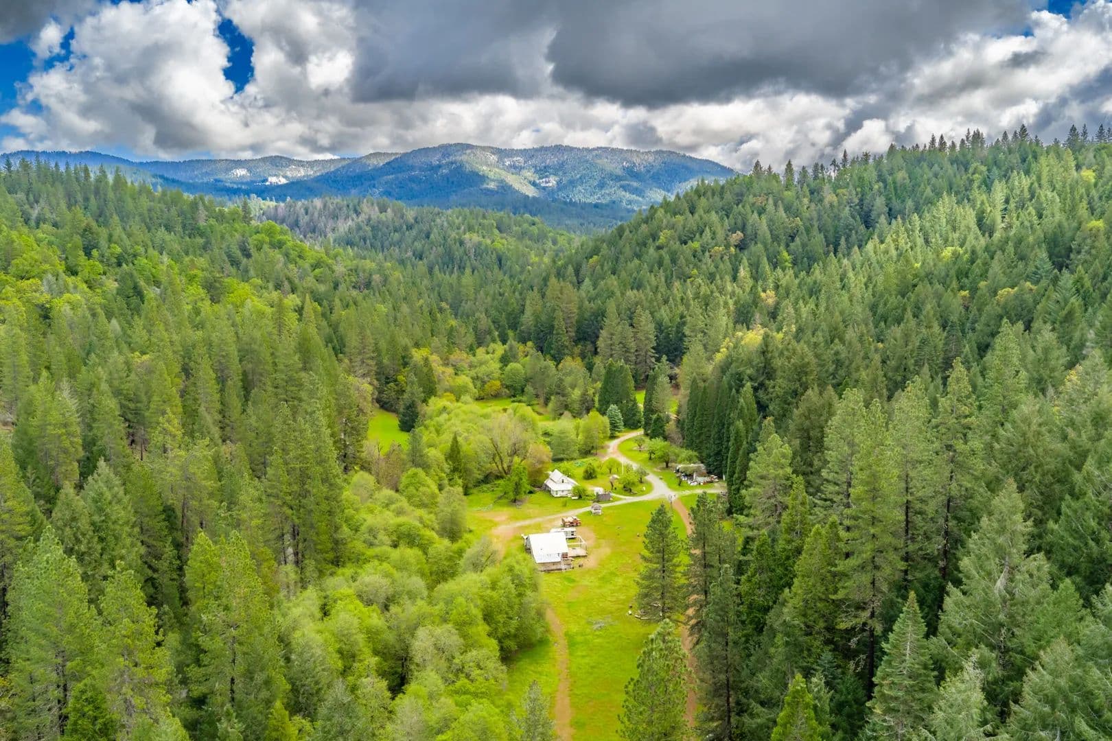
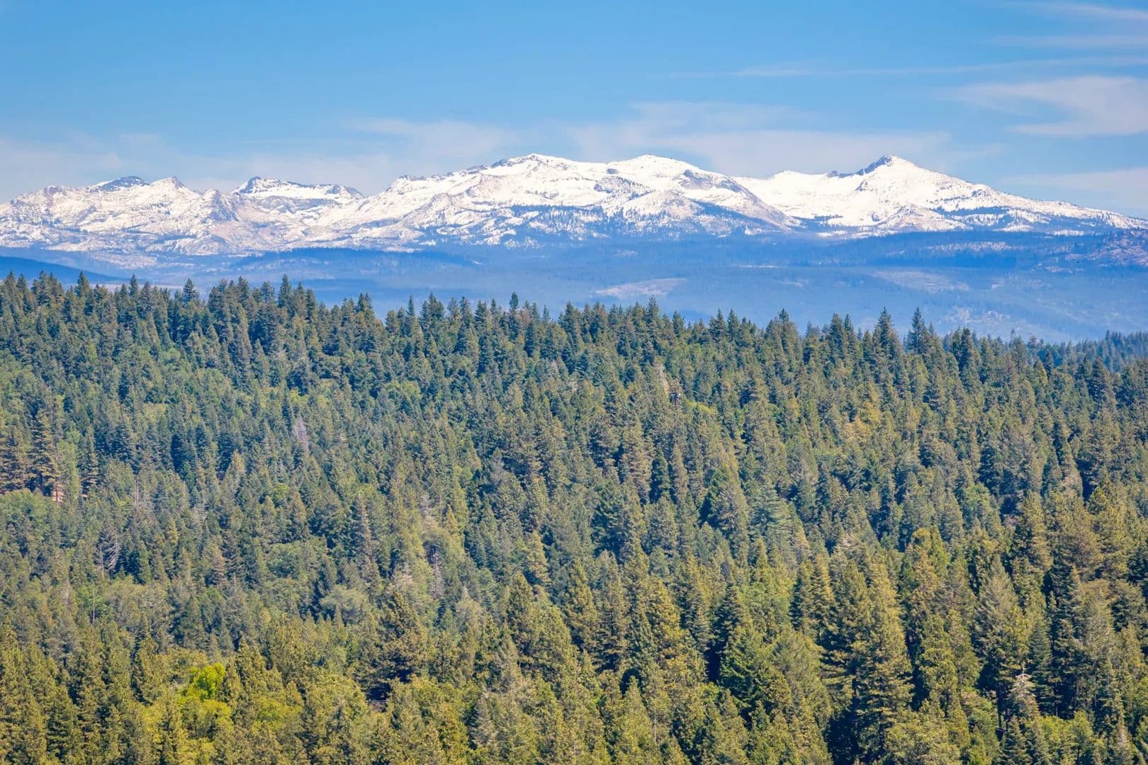
Round Spur Ranch is a breathtaking 251.5 acre retreat located in El Dorado County and the heart of California's Gold Country. Just minutes from the historic gold discovery sites along the American River, the property consists of 2 legal parcels, and is a short 30 minute drive to the cities of Auburn to the north and Placerville to the south along Highway 49, and for the off-road enthusiast, the world-famous Rubicon Trail to the east.Land This exceptional property provides excellent opportunity for on- or off-grid living. The property is comprised of two adjacent parcels totaling 251.5 acres. Parcel 1 is 157.8 acres and Parcel 2 is 93.7 acres. Both parcels are zoned RL-40 (40-acre- Rural Lands), allowing the property to be subdivided into multiple 40-acre minimum parcels*. Seller financing options available for well-qualified buyer.The land includes mild to moderately sloped ridgetops, and moderately steep canyons forested with a rich variety of trees, shrubs and grasses. Some of the tree species include Black Oak, Madrone, Live Oak, Douglas Fir, Ponderosa Pine, Sugar Pine, and Incense Cedar. Multiple year-round and seasonal creeks runs through both parcels ,and a seasonal pond is located on Parcel 2. A 5 +/- acre ridgetop orchard is planted in English Walnut on Parcel 2 and suitable for other crops as well (see Map).The property has multiple access points: Bear Creek Road along the western boundary provides 1 non-gated and 2 gated driveways, Dewer Road (gated) at the south end of the property, and Round Spur (Forest Road 12N81B, gated) at the eastern boundary. The internal roads provide access throughout the property with most roads leading to El Dorado National Forest out the eastern gate.. There are several excellent ridgetop building sites on the property that could be developed for a variety of uses, including: homes, outbuildings, cabins, recreational retreat facilities, storage for off-road and recreational vehicles, equipment and more. This seemingly untouched land includes rich habitat for a variety of wildlife and supplies a wide range of opportunities for the outdoor enthusiast.*Subject to El Dorado County and other local zoning and development standards and guidelines.See the Recreation section for more.Improvements The property includes a 50′ vintage 1 bedroom-1 bath mobile home, a 35′ mobile office trailer converted to a 1 bedroom- 1/2 bath cabin, a 16′ camp trailer, a 10’X10′ storage shed, and a garage consisting of two 40′ storage containers with roof. Water to both parcels is provided by a private 220′ well that was capable of producing over 100 gallons of water per minute when it was installed. Water is connected by underground service at the 50′ mobile home, the 35′ office trailer, and irrigation lines are run into the orchard. Power is provided at a 200A service drop at the primary ridgetop, with underground service to the well, and overhead service to the trailer compound. Primary legal access is via a gated driveway off Bear Creek Road with multiple access roads (historically used for logging) meander throughout the property.Recreation The mountain communities of El Dorado County provide year-around delight and adventure. Lake Tahoe is within a short drive east on US-50 or I-80 with world-class amenities at Heavenly Mountain Resort, Palisades Tahoe, Northstar California Resort, Sierra-at-Tahoe Resort, Kirkwood Mountain Resort, and more featuring some of the west’s best powder skiing, is just over an hour away. The world-famous Rubicon Trail is nearby along with hundreds of miles of trails for your off-road adventures. The mighty American River and its branches and tributaries are only minutes away providing tremendous flyfishing opportunities along with white-water rafting and kayaking. There are a multitude of mountain lakes with a short drive including Stumpy Meadows Reservoir, Ice House Reservoir, Union Valley Reservoir, Jenkinson Lake and many more. The Sierra Nevadas provide endless outdoor recreation activities including white-water rafting, gold prospecting, hiking, biking, camping, hunting, fishing, boating, wine tasting, dining, golfing, winter snow sports, summer water sports and everything in between are found in every direction. A sportsperson’s paradise with endless recreational opportunities. See the Resource Links for much more information.Agriculture The property is heavily forested with potential timber harvest income with new tree growth since last logged over 30 years ago. The ridgetop orchard is planted in English Walnut and may be suitable for additional crops in the 3e soil classification (see Soils Report).Water/Mineral Rights & Natural Resources Water and mineral rights convey with the property.Region & Climate This private and secluded Garden Valley property is your gateway to El Dorado County adventures. Year-round sports, recreation, hunting and fishing are at your footsteps with numerous lakes, rivers, streams, campgrounds and public lands throughout the region. Sitting at just over 2,000 feet in elevation, the area provides excellent climate and weather for visitors and year-round residents. The quaint mountain towns nearby provide ample amenities including restaurants,. shopping, farmers’ markets, and artisan crafts.History Garden Valley, California lies between Georgetown and Coloma in El Dorado County, at the junction of Irish and Empire Creeks, and had a post office by 1852. It is said that the name was given because it was more profitable to grow vegetables there than to mine. However, it was a busy mining area by 1852.Tucked in the heart of El Dorado County, Garden Valley is a peaceful and picturesque Californian community that offers an idyllic retreat from the bustling city life, while being comfortably nestled between Sacramento and South Lake Tahoe. It boasts a winning combination of serene surroundings of the countryside, the tranquil ambiance of a small-town, and scenic vistas of the landscape, characterized by undulating hills, extensive forests, and crystal-clear creeks.The outdoor opportunities in and around Garden Valley are nearly limitless. The picturesque Coloma-Lotus Valley is rich in history, with class 3 rated South Fork of the American River offering unrivaled sports such as white-water rafting and kayaking. The landscape has numerous parks, extensive hiking and horseback riding trails, not to mention a variety of wineries and restaurants within a few minute’s drive.Location Garden Valley also enjoys an enviable location near the historic city of Placerville, known for its outdoor activities set against the backdrop of farms, vineyards, and orchards. The strategic positioning gives you the most of two worlds: just an hour away from vast metropolitan delights in Sacramento and recreational possibilities in South Lake Tahoe. The city is around half a day’s drive from San Francisco or Reno and a few minutes to Georgetown. The close proximity to Hwys 193, 49, and 50 also makes commuting and traveling significantly convenient.
Black Ridge Estate
$189,000
20 Acres
Greenwood, California, 95635
The Black Ridge Estate is a 20- Acre vacant property located in Greenwood, California. With RE-10 zoning allowing a potential lot split, the property features multiple potential hilltop build sites, an abundance of wildlife, hardwood and softwood tree species, and a seasonal creek. Land The private and secluded 20-acre property is accessed by Black Ridge Road, a well-maintained private road, and is ½ mile off of Greenwood Road. Electric service is available from PG&E from a residential distribution line adjacent to the property boundary along Black Ridge Road. Georgetown Public Utility District water is available via a nearby connection. The moderately sloped terrain offers tremendous habitat for wild animals as well as plenty of forage for livestock. The property has an abundance of oak, pine, and douglas fir trees as well as a variety of native shrubs.Recreation El Dorado County is a paradise for all who enjoy the great outdoors. The nearby North, Middle, and South Forks of the American River provide excellent recreation opportunities on the water including fly fishing the clear cold waters and white water rafting adventures along the river canyons, More fishing and boating adventures are available at nearby Folsom Lake, and Stumpy Meadows Reservoir. Within a short drive, El Dorado National Forest provides an expansive array of recreation activities in the Sierra Nevada High Country all the way to the Lake Tahoe basin.Water/Mineral Rights & Natural Resources Water and mineral rights convey.Region & Climate The Sierra Nevada Foothills are renowned for the mild climate with cool winters transitioning to blue skies and warm temperatures through the spring, summer, and fall.History El Dorado County is California’s Gold Country. Early pioneers and miners flocked to the area in pursuit of riches after the discovery of gold at Coloma. Evidence of historic mining activities can be found throughout the County.Location Greenwood is located on the Georgetown Divide in El Dorado County between the Middle and South Forks of the American River. The communities of Georgetown, Cool, Garden Valley, Lotus, and Coloma are only a short drive away. Placerville, the county seat, to the south is a 30 minute drive and Auburn to the north is 20 minutes away in Placer County along the historic Highway 49. California’s capital, Sacramento, is approximately 45 minutes away via Interstate 80 or US 50.
The Albright Ranch
$1,349,000
110.83 Acres
Somerset, California, 95684
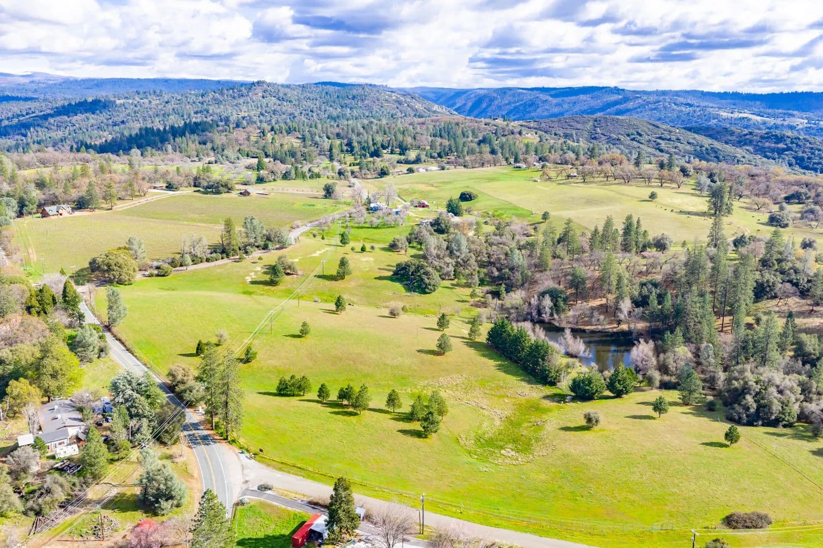
Embrace California's western heritage on the historic Albright Ranch, a 110-acre working cattle ranch located in Somerset, El Dorado County. This property features a 1940's vintage ranch house, large barn, workshop, greenhouse, guest house, pear orchard, multiple water wells, 2-acre bass pond, and is fully fenced and crossfenced. The gently rolling terrain has mature oaks, pines, and open grasslands suitable for a wide variety of wildlife.Land The Albright Ranch is a 110-acre cattle ranch located in Somerset, California. Once a portion of the historic Meyer Ranch nearby, the ranch is situated between the North and Middle Forks of the Consumnes River. The ranch is a short 20 minute drive to Placerville to the north and Jackson to the South. Sitting at an elevation of approximately 2,400 feet, the gently rolling hills of the ranch provide mature native oaks, conifers, and open grasslands suitable for a wide variety of livestock and wildlife. Water is abundant on the ranch with multiple natural springs, a year-round pond, and several productive water wells. Located in the Fairplay AVA wine growing region and surrounded by neighboring vineyards, the ranch’s favorable soils may have the potential for planting a vineyard, expanded fruit orchard, or other crops. The Ranch is under an active Williamson Act conservation contract.Improvements The Albright Ranch features a 1940’s vintage ranch house with 2,439 sq ft, 4-plus bedrooms, 3 full baths, and a large outdoor deck. The detached 1,300 sq ft garage and workshop provides plenty of room for tools, equipment, and toys. Within the ranch house complex, a large 1,800 sq ft barn includes a tackroom, hay storage, office, and blacksmith shop. Attached to the barn is 6 enclosed and covered horse stalls. A corral provides an area to contain and sort livestock, and includes a squeeze chute. Nearby is a 450 sq ft greenhouse to exercise your green thumb. The Ranch also includes a 1,800 sq foot manufactured home suitable for a rental, guest house, or onsite housing for a hired hand. There are multiple water wells that provide domestic water to the ranch and to the livestock. The 1-acre orchard is planted in mature Asian Pears. The natural springs on the ranch feed an approximate 2-acre year-round bass pond behind an earthen dam. Several other smaller seasonal ponds with dams are located throughout the property. The Ranch is fully fenced along the perimeter and crossfenced creating multiple pastures.Recreation The interior of the Ranch is accessible via a network of roads and trails that brings visitors through open grasslands, oak woodlands, and mixed conifer forest. Perfect for between-the-ears trail rides on horseback or on ATVs. For the hunter, the varied terrain and vegetation offers excellent habitat for for wildlife including wild turkey and blacktail deer. The 2-acre spring-fed pond is the perfect opportunity to get a line wet and reel in a bass. Within just a short drive, the lands of the El Dorado National Forest, with thousands of acres to explore, hundreds of miles of trails, cold mountain streams, and high-country alpine lakes, is a outdoorsman’s paradise.Agriculture The Albright Ranch is primarily used currently for cattle grazing on its open grasslands and woodlands. Situated in the Fairplay AVA, the upper portion of the ranch along Grizzly Flat Road was once planted in wine grapes and currently features a small 1-acre Asian Pear orchard and several large walnut trees near the ranch house. With it rich soils and plentiful water, the Ranch can support a variety of agricultural uses and is subject to an active Williamson Act conservation contract.Region & Climate Somerset, California, is located in the Sierra Foothills and experiences a climate defined by its elevation, with warm, dry summers and cool, wet winters. This seasonal variety supports a range of outdoor activities, from hiking and water sports to wine tasting and camping.Outdoor activities:Hiking and trailsThe Sly Park Recreation Area is a key destination near Somerset, offering an 8.5-mile loop trail around Jenkinson Lake suitable for hiking, walking, and mountain biking. The area also features a popular waterfall.The Eldorado National Forest borders the area and provides numerous trails for more extensive hiking.For an easy, scenic hike, an unnamed trail leads to a waterfall on Mormon Emigrant Trail and offers swimming opportunities in the cold water during warm weather.Cronan Ranch Regional Trails Park, slightly further afield, offers trails with views of the American RiverWater recreationJenkinson Lake, within Sly Park Recreation Area, is a hub for water activities. Visitors can enjoy swimming, fishing, and boating, with boat rentals available.The South Fork American River offers opportunities for whitewater rafting, particularly during the late spring and summer months.CampingThe region has several campgrounds, including locations near Jenkinson Lake at Sly Park Recreation Area and KOA sites that cater to both tent campers and RVs.Wine tasting and vineyard toursAs part of the Fair Play American Viticultural Area (AVA), Somerset is surrounded by vineyards that offer outdoor tasting experiences. Wineries often have scenic grounds and patios where guests can relax and enjoy the scenery.Saluti Cellars offers unique “EquWine Experiences,” combining horseback riding through the vineyards with wine tasting.Climate and seasonal featuresSummer: The summer months are warm and dry, with average high temperatures reaching into the low 90s °F (around 33 °C) in July. The higher elevation means evenings are much cooler, which is beneficial for both camping and grape growing.Autumn: The weather in the fall is mild, and the changing foliage creates a scenic landscape for outdoor activities. Wine harvest festivals are a popular attraction during this time.Winter: Winters are cool and wet, with December being one of the coldest and wettest months. Rain and cooler temperatures mean fewer crowds and a peaceful atmosphere.Spring: Spring brings mild temperatures and vibrant wildflowers, creating ideal conditions for hiking and exploring.History The town of Somerset, California, was founded in the mid-19th century during the Gold Rush as a trading post. In the modern era, it has become known as a peaceful wine-growing region in the Sierra Nevada foothills.Early history and Gold Rush eraEstablishment: Somerset was settled in 1856 by former residents of Somerset, Ohio, who named the new community after their hometown.Trading post: In its early years, Somerset served as a small but important trading stop for miners and others traveling to nearby mining towns like Grizzly Flat, Fair Play, and Indian Diggings.The Somerset Hotel: Around 1864, the Somerset Hotel was a prominent local landmark and featured in an important story in El Dorado County’s history. It was a site connected to the infamous Bullion Bend stagecoach robbery, which took place nearby.Pony Express trail: Some historical accounts suggest the area was traversed by the Pony Express. The nearby community of Meyers was a registered Pony Express station.Location The Albright Ranch is located in Somerset, El Dorado County, California. It sits just 20 minutes south of Placerville and 40 minutes north of Jackson off of Grizzly Flat Road. Sacramento and the Sacramento International Airport are approximately 1 hour away to the west. Lake Tahoe is a 1 hour 20 minute drive to the east.
Hammil Valley Estate
$335,000
64.5 Acres
Hammil, California, 93514
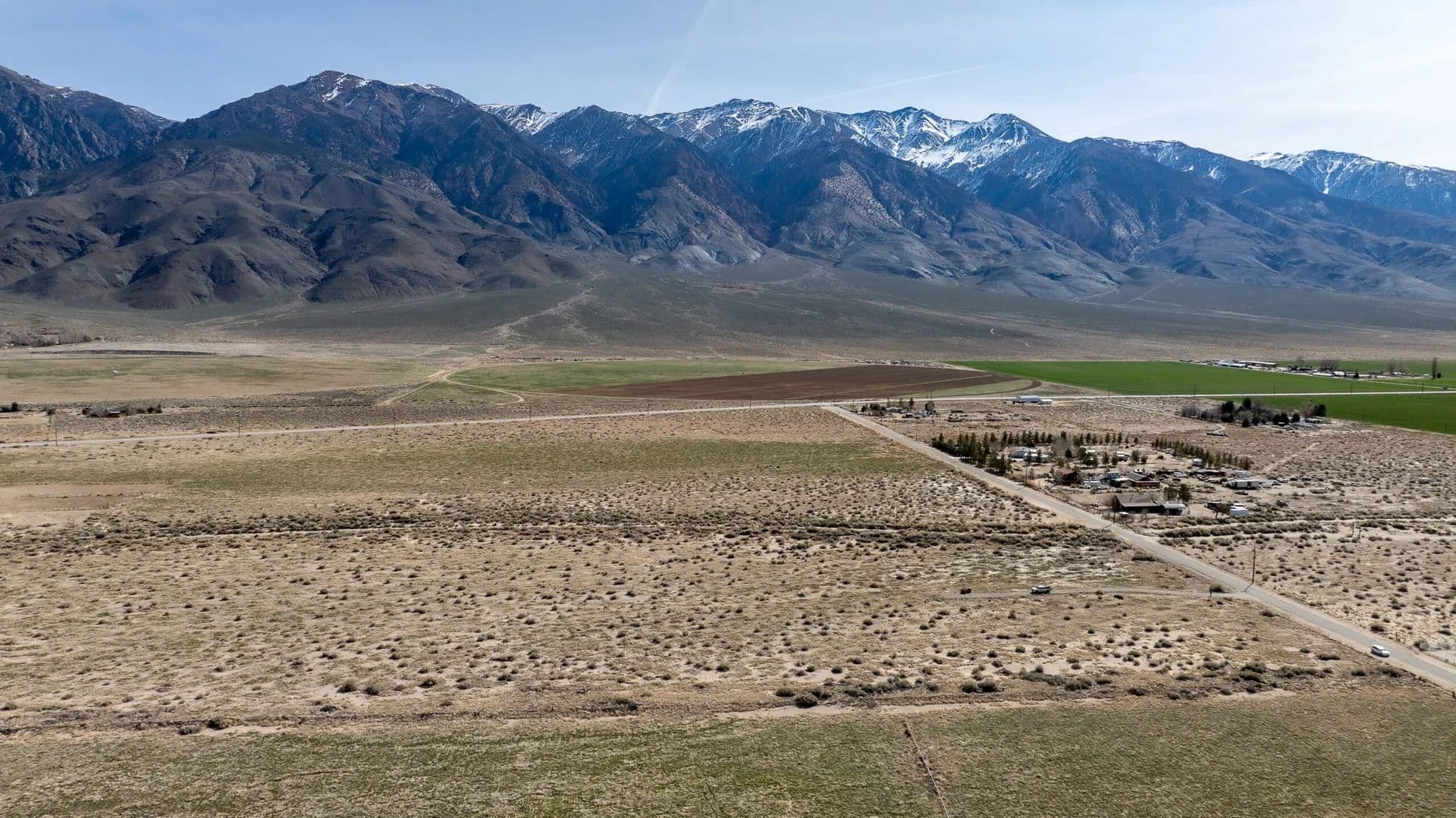
Premier corner lot at Hwy 6 & Dawson Ranch Rd. Level high-desert valley floor (4,576 ft elev) with panoramic White Mtn & Sierra views. New 500-ft commercial well delivers 400 GPM—rare abundant water for irrigation, livestock, crops. Alluvial soils over Bishop Tuff respond well to water. Equestrian/ag zoned, buildable, year-round access. Ideal for ranch, estate, farm or investment. Land Offered in the heart of California’s scenic Eastern Sierra, this exceptional 64.5-acre parcel commands a premier corner location at Highway 6 and Dawson Ranch Road in Hammil Valley—offering unmatched visibility, accessibility, and big-sky appeal just minutes from Bishop.The terrain is predominantly level valley floor with gentle alluvial slopes, sitting at approximately 4,576 feet elevation. This wide-open, highly buildable landscape delivers panoramic mountain views and year-round access, making it an ideal canvas for your vision—whether a premier equestrian estate, productive agricultural operation, private family compound, or thoughtful subdivision potential.Water security sets this property apart: a newly drilled commercial well reaches 500 feet and produces an impressive 400 GPM—providing abundant, reliable supply for irrigation, livestock, crops, or development needs in this high-desert environment.Vegetation features classic high-desert native communities, including sagebrush scrub and shadscale across the valley floor, with pinyon-juniper woodlands on the surrounding fans and rises. The open character lends itself beautifully to pasture improvements, hay production, or enhanced riparian zones near water features—blending natural low-maintenance appeal with productive potential.Soils are primarily coarse-textured alluvial mixes of sand and silt over volcanic Bishop Tuff—well-draining and responsive to irrigation. These fertile valley soils have supported agriculture in the region for generations and stand ready to thrive with the new high-capacity water source.Zoned for equestrian and agricultural uses, this corner parcel combines rare water abundance, versatile flat acreage, stunning Eastern Sierra vistas, and strong highway frontage into one outstanding opportunity. Perfect for the discerning buyer seeking legacy land in one of the West’s most iconic landscapes.Improvements A new commercial water well, drilled to 500 feet, provides a robust 400 GPM flow—delivering reliable, high-capacity water essential for irrigation, livestock, agriculture, or future development. Access is supported by existing roads, including direct frontage along Highway 6 and Dawson Ranch Road for excellent year-round entry and internal circulation across the level terrain. Perimeter and boundary fencing establishes clear property lines, offers security for potential equestrian or agricultural operations, and helps contain livestock while defining the parcel’s expansive boundaries. These key upgrades—combined with the flat, buildable land—position the property as a ready-to-improve foundation for a ranch, estate, or productive venture in the Eastern Sierra.Recreation Hammil Valley Estate places owners at the gateway to the Eastern Sierra’s world-class outdoor playground. Just minutes from Bishop and with quick access to US-395, the property serves as an ideal base for year-round adventures amid stunning high-desert and alpine landscapes.Hiking & Backpacking Endless trails await in the surrounding Inyo National Forest and Eastern Sierra. Popular nearby options include day hikes in Bishop Creek Canyon, Little Lakes Valley, and the Buttermilk Country for scenic loops with mountain views. For bigger challenges, access the John Muir Trail, Pacific Crest Trail segments, or routes to alpine lakes and passes—perfect for multi-day backpacking with panoramic Sierra Nevada vistas.Fishing The Eastern Sierra is a renowned trout fishing paradise. Cast lines in the Owens River (wild trout waters just minutes away), Pleasant Valley Reservoir, or head west to Bishop Creek Canyon for stocked alpine lakes and streams teeming with rainbow, brown, and brook trout. Nearby Millpond Recreation Area offers family-friendly pond fishing, while guided trips target trophy catches.Hunting Mono County’s vast public lands (over 90% open) support seasonal big game pursuits like mule deer and black bear, plus upland birds, quail, and small game. The property is located in the premium X9a zone for deer.Other ActivitiesMountain Biking & Road Cycling — Explore Buttermilk trails or Owens Valley routes with varied terrain and big-sky scenery.Rock Climbing & Bouldering — World-famous Bishop bouldering areas (e.g., Buttermilks) offer granite problems for all levels.Horseback Riding & Equestrian — Aligns perfectly with the property’s zoning; pack stations offer guided rides into the Sierra.Wildlife Viewing & Photography — Spot mule deer, birds, and more in the high-desert sagebrush and nearby canyons.Off-Road & Scenic Drives — Highway frontage and proximity to backcountry roads for 4×4 exploration.Winter Pursuits When snow blankets the region, head north to Mammoth Lakes and Mammoth Mountain—about 42 miles (roughly 45-minute drive) from Bishop—for legendary winter action. Mammoth Mountain offers over 3,500 acres of premier skiing and snowboarding terrain with long seasons, high lifts, and epic powder. For non-skiers or variety, enjoy cross-country skiing and snowshoeing on groomed trails at Tamarack Cross-Country Ski Center (19+ miles), guided snowmobile adventures through snowy forests, family-friendly tubing and sledding at Woolly’s Adventure Summit, thrilling Mountain Coaster rides, scenic gondola trips for summit views, ice skating in town, or relaxed hot springs soaks. Additional options include snowcat tours, winter ziplines, and village events—making Mammoth a complete winter destination for all ages and abilities.From the parcel’s level valley floor, transition seamlessly to these pursuits—whether a quick evening fish on the Owens or a full-day powder day at Mammoth. This location combines remote tranquility with easy access to Bishop’s amenities and nearby alpine thrills, creating a dream setup for an active Eastern Sierra lifestyle.Agriculture This Hammil Valley property holds strong agricultural potential, bolstered by its level alluvial terrain, coarse-textured sand and silt soils over volcanic Bishop Tuff, and a high-capacity commercial well delivering 400 GPM from 500 feet—providing abundant irrigation water critical in this high-desert environment. These fertile, well-draining soils respond excellently to water application, supporting productive crop cultivation, hay production, or pasture for livestock. The property’s equestrian and agricultural zoning, combined with perimeter fencing and highway access, makes it ideal for a viable farming operation, irrigated fields, or expanded ranching.In the surrounding Tri-Valley area (including Hammil, Chalfant, and Benton valleys), agriculture remains a cornerstone of the local economy and rural character. Historically and currently dominated by irrigated cropland—primarily alfalfa hay, which leads field crop production in Mono County—along with other crops like seed potatoes, garlic, carrots, and additional hay varieties. Livestock grazing (cattle and sheep) is widespread on rangeland and pastures, contributing significantly to regional output. Mono County’s field crops, including substantial alfalfa, drive much of the agricultural value, with conservation efforts preserving prime soils and open-space farmlands. This established agricultural heritage, supported by local policies encouraging retention of ag lands, positions the parcel as a prime opportunity for sustainable, water-secure farming or ranching in the Eastern Sierra.Region & Climate Hammil Valley lies in the picturesque Tri-Valley region of Mono County, California (including Hammil, Chalfant, and Benton valleys), a serene high-desert basin in the Eastern Sierra just north of Bishop. This rural area features wide-open sagebrush landscapes, irrigated farmlands, and small communities surrounded by dramatic mountain ranges, offering a peaceful, low-density lifestyle with easy access to Bishop’s amenities like shops, schools, and services.The region supports a vibrant mix of outdoor and community activities, from local farming and equestrian events to exploring nearby Inyo National Forest trails, Owens River fishing, and world-class bouldering in the Buttermilks. Seasonal highlights include summer hiking and fall color viewing, with quick drives to Mammoth Lakes for alpine adventures.The climate is arid high-desert with abundant sunshine (over 300 sunny days annually), hot dry summers (highs often 90–98°F in July), and cool winters (lows in the 20s°F, highs 50–60°F). Annual precipitation averages around 5–6 inches, mostly as winter rain with light snowfall (about 6–8 inches in the valley, far less than higher elevations). Summers bring low humidity and clear skies ideal for outdoor pursuits, while winters offer mild days with occasional snow, transitioning to nearby Mammoth Mountain’s heavy powder for skiing. This dry, sunny pattern supports agriculture like alfalfa hay while providing year-round enjoyment of the Eastern Sierra’s natural beauty.History Hammil Valley traces its European-American settlement to the 1870s when three brothers—William, Hugh, and Robert Hammil—homesteaded the area around 1870, giving the valley its name through their pioneering ranching efforts. The region boomed briefly with the arrival of the Carson and Colorado Railroad in 1883, which established a station named after the Hammil brothers, supporting transportation for local agriculture and connecting to broader mining and ranching networks tied to the Bodie gold rush era. Nearby ranches, like the historic Cinnamon Ranch (dating to 1864), highlight over 150 years of continuous agricultural use, primarily irrigated alfalfa hay and livestock grazing on the fertile alluvial soils. This high-desert basin has long sustained a rural, farming lifestyle amid Native American heritage and Eastern Sierra landscapes, evolving into a preserved agricultural stronghold with policies protecting prime farmlands and open space.Location Hammil Valley Estate ) is situated in the scenic Hammil Valley within Mono County’s Tri-Valley region (encompassing Hammil, Chalfant, and Benton valleys), along the prominent corner of Highway 6 and Dawson Ranch Road. Positioned in the high-desert Eastern Sierra of California, it lies approximately 15–20 miles north of Bishop via US-395 and Highway 6, offering quick highway access while maintaining a rural, open-space setting amid sagebrush plains and surrounding mountain ranges.Nearest TownsBishop (largest nearby community): About 15–20 miles south, providing essential amenities including grocery stores, restaurants, medical facilities, schools, hardware stores, and outdoor gear shops.Smaller nearby areas include Chalfant Valley (south) and Benton (north), with limited services but contributing to the Tri-Valley’s agricultural and residential character.Nearest AirportsEastern Sierra Regional Airport (BIH) in Bishop: Roughly 15–20 miles south, offering seasonal commercial flights via United Airlines from San Francisco (SFO) and Denver (DEN), plus general aviation services—ideal for convenient regional access.Mammoth Yosemite Airport (MMH): About 45–50 miles north (near Mammoth Lakes), with charter and seasonal flights from Southern California hubs, serving as another gateway for visitors heading to higher-elevation recreation.Closest Amenities Daily essentials and conveniences are readily available in Bishop, just a short drive away, including shopping, dining, healthcare, fuel, and services. The property’s highway frontage ensures easy connectivity, while the surrounding area emphasizes rural tranquility with proximity to outdoor pursuits like fishing on the Owens River, hiking in Inyo National Forest, and winter sports at Mammoth Mountain. This balance of seclusion and accessibility makes it perfect for a legacy ranch or estate in the Eastern Sierra. Contact Hayden Outdoors for maps, driving directions, or additional location insights.
Blue Mountain Event Center and Ranch
$2,300,000
217 Acres
Wilseyville, California, 95257
The Blue Mountain Event Center and Ranch is an exceptional 217-acre recreational ranch and private retreat located near Wilseyville, in the scenic foothills of Calaveras County, California. This versatile legacy property delivers unparalleled outdoor recreation and event hosting opportunities with room for music festivals, weddings, family gatherings, and camping along almost 1 mile of the Licking Fork of the Mokelumne River.Land The Blue Mountain Event Center and Ranch encompasses approximately 217 secluded acres of A1-zoned agricultural land in the scenic foothills of Calaveras County.The layout integrates natural water features with recreational and timber areas: nearly one mile of frontage along the year-round Licking Fork of the Mokelumne River, a tranquil pond fed by a freshwater ditch, sprawling meadows ideal for gatherings, and miles of trails weaving throughout the property for hiking, equestrian use, and OHV adventures. Improvements include a 1924 farmhouse, modular home, iconic event barn with stage and bar, storage buildings, three wells, and water storage tanks, all positioned for practical access, while the balance remains open for events, camping, or expansion. Access includes a short section of packed gravel county road and a bridge.Terrain varies from flatter meadow and river-bottom areas to steeper, rolling hillsides suited for dirt bike and OHV riding, creating a dynamic, private retreat with natural elevation changes and abundant wildlife habitat.Vegetation features a productive timber stand (estimated 2.5–3.0 MBF), lush grassy meadows, historic apple trees dating to the 1800s (likely planted in the 1850s), and diverse native cover that sustains wildlife. Water and mineral rights enhance the off-grid parcel’s self-sufficiency. Overall, the property blends riverine, meadow, and wooded zones into a versatile, nature-immersed landscape perfect for recreation and events.Improvements The property includes two primary residences and a collection of functional event and support structures on its 217-acre A1-zoned ranch parcel.1924 Farmhouse: A rustic single-family ranch-style home built in 1924, approximately 1,428 sq ft. It offers classic Gold Country charm but requires renovation.Modular Home: A second single-family residence, also in need of renovation.Iconic Old Barn/Event Venue: A historic barn thoughtfully converted for large gatherings, featuring a built-in performance stage and bar—ideal for festivals, weddings, and events.Fish Hatchery: Includes incubation building and rearing ponds, in need of renovation.Additional Structures: Includes multiple storage buildings for equipment and supplies, water storage tanks, three water wells, and convenient outdoor flush toilets.These improvements blend heritage character with practical event and off-grid functionality,Recreation The 217-acre private ranch offers a diverse array of year-round recreational activities centered around its natural features and established event infrastructure. Water-based recreation includes trout fishing in the year-round Licking Fork of the Mokelumne River and the on-site pond. Extensive trail systems support hiking, equestrian riding, mountain biking, and OHV adventures, with steep terrain challenging advanced dirt bike and quad riders while offering beginner trails and kid-friendly areas.The property excels as a large-scale event venue, hosting music festivals, fire and flow arts gatherings (e.g., FireDrums), onewheel/EUC races (e.g., Shredfest), weddings, retreats, and family camping across multiple days. A sprawling meadow provide space for picnics, BBQs, and group activities, while miles of scenic trails wind through timber stands, historic apple orchard, and wildlife-rich areas for nature immersion and exploration. Off-grid seclusion enhances the experience for veterans’ events, charitable gatherings, and multi-day camping escapades in a serene Gold Country setting.Additional passive recreation includes wildlife viewing and relaxing in the foothills landscape, making it ideal for both high-energy adventures and peaceful retreats.Agriculture The 217-acre property is zoned A1 (General Agriculture), allowing a wide range of agricultural uses. Water and mineral rights support potential future agricultural activity or hobby-scale operations.Farming & Cattle: The open meadow could support limited grazing, hay production, or small-scale livestock, consistent with typical Calaveras County foothill ranches.Crops: A historic apple orchard features old trees dating to the 1800s (likely planted in the 1850s during the Gold Rush era), adding legacy character and potential for small-scale fruit harvesting or agritourism.Timberland: A modest timber stand is present, estimated at 2.5–3.0 MBF. The site has deep historical ties to timber—originally a nearby 1882 sawmill location with operations continuing into the late 1940s under the Mitchell Mill name.Overall, the land’s agricultural attributes are legacy and permissive rather than active, offering buyers flexibility to pursue hobby farming, grazing, orchard restoration, or timber management alongside its established event and recreation uses.Water/Mineral Rights & Natural Resources The 217-acre A1-zoned agricultural property includes conveyed water rights and mineral rights, as key amenities supporting its off-grid, self-sufficient character.Water Rights: These encompass riparian rights associated with nearly one mile of frontage on the year-round Licking Fork of the Mokelumne River, plus supporting infrastructure including three productive wells, water storage tanks, and a pond fed by a pristine freshwater ditch. The rights enable beneficial uses for domestic, recreational (fishing, swimming), event-related, and potential agricultural or livestock needs without municipal water dependency.The features collectively provide reliable water resources typical of foothill ranches with historical ditch and river access.Mineral Rights: Full mineral rights are included and conveyed with the surface estate. This is a significant plus in Calaveras County’s historic Gold Country.These rights enhance the property’s versatility for recreation, events, and legacy agricultural/timber uses.Region & Climate Wilseyville is an unincorporated community in Calaveras County, California, nestled in the Sierra Nevada foothills at an elevation of approximately 2,769 feet. This tranquil area is defined by its rugged landscape of rolling hills and dense forests, offering a variety of outdoor regional activities including hiking, fishing in the Mokelumne River, and competitive dirt bike racing at the annual Wilseyville Hare Scramble. The local climate features distinct seasons; summers are typically warm with average highs reaching the upper 80s in July, while winters are cool with temperatures often dropping into the mid-30s. Precipitation is concentrated in the cooler months, with December and February historically receiving the most rainfall—averaging over 11 inches each—while summer months like July and August remain nearly dry.

Lazy Buck-125
$1,250,000
125.68 Acres
Placerville, California, 95667
Incredible opportunity to own over 125 acres of rolling, oak-covered hills in south El Dorado County. Just minutes from Historic Downtown Placerville, the park-like property features amazing ridge top views of the snow-capped peaks to the East, Consumnes River Canyon, and vinyards of the Fairplay Wine Region to the South, and points beyond. The south-facing rolling hills provide sun-warmed grasslands and cool shade under the majestic oaks. Land The Lazy Buck-125 consists of 125.68 acres of oak woodlands zoned RL-40 with a lot split possible into 3 approximately 40 acre parcels. With hilltop locations throughout, favorable build sites provide extensive view potential of the surrounding Sierra Nevada Foothills and Consumnes River Canyon. The grassy hills and meadows offer plenty of forage for livestock and wildlife.Improvements The property contains a system of unpaved roads and trails for access to the south-facing hilltops, Primary gated access is from the paved and private Palace Lane , with additional gated access from Bucks Bar Road on the east boundary and Ranch Road on the west. El Dorado Irrigation District’s Crawford Ditch traverses the property and provides access to residential and irrigation water. The property is fenced along the west, south, and east boundary lines.Recreation El Dorado County offers premier year-round outdoor recreation, featuring whitewater rafting on the American River, skiing/snowboarding at South Lake Tahoe resorts (Heavenly, Kirkwood, Sierra-at-Tahoe), and extensive hiking in the Desolation Wilderness. Key spots include the Rubicon Trail for OHV, Sly Park for boating/camping, and Cronan Ranch for biking, with abundant fishing and gold panning opportunities.Water Activities & FishingSouth Fork American River: Famous for whitewater rafting, kayaking, and fishing.Lake Tahoe: Offers swimming, boating, kayaking, and paddleboarding.Loon Lake & Jenkinson Lake: Popular for boating, fishing, and swimming, with camping available at Sly Park Recreation Area.Lake Natoma: Known for crew races, sailing, and kayaking.Hiking, Biking & TrailsDesolation Wilderness: Nearly 64,000 acres of alpine forest and granite peaks, perfect for hiking and backpacking (permit required).Cronan Ranch Regional Trails Park: Features 12 miles of trails for hiking, biking, and horseback riding along the American River.El Dorado National Forest: Offers extensive hiking, horseback riding, and cycling trails.Rubicon Trail: World-renowned for off-highway vehicle (OHV) access.Folsom Lake State Recreation Area: Features a 32-mile bike path.Camping & ParksSly Park Recreation Area: Features 191 campsites, hiking, and equestrian trails.Henningsen Lotus Park: 51-acre park with a boat launch and beach area on the American River.Pioneer Park: Features an equestrian arena and sports fields.El Dorado Hills Community Park: Includes a skate park, dog park, and aquatic center.Winter SportsSkiing/Snowboarding: Access to top-tier resorts, including Heavenly, Kirkwood, and Sierra-at-Tahoe.Snowshoeing/Cross-Country Skiing: Available in the Eldorado National Forest and Desolation Wilderness.Wine Tours and Tasting: El Dorado County and nearby Amador County are home to a multitude of of vinyards and tasting rooms for the wine-lover.Additional ActivitiesGold Panning: Available in various rivers, particularly near Coloma.Rock Climbing: Popular at Lover’s Leap.Picnicking: Numerous sites in the national forest and county parks.Apple Hill: Located near Placerville, offering seasonal, family-friendly orchard activities. Agriculture Currently used for cattle grazing, the property has plenty of forage and water access for livestock including cattle, horses, goats, and sheep. The surrounding area is well known for wine grapes with the Fairplay Wine Region and Amador’s Shanandoah Valley just a short drive away.Region & Climate Placerville area features a Mediterranean climate with four distinct seasons, characterized by hot, dry summers and cool, wet winters, typically avoiding heavy valley fog. Located around 2,000 ft elevation, it experiences average July highs around 93°F and January lows near 32°F–38°F. Annual rainfall averages roughly 38 inches, with light, infrequent snow..Location The Lazy Busk-125 is 15 minutes from downtown Placerville and US-50, and less than 1 hour from California’s Capital City, Sacramento. The Sacramento International Airport is approximately 1 hour away. A short drive to the east is El Dorado National Forest and the ski areas of Lake Tahoe.
Sly Park Retreat
$1,600,000
57.17 Acres
Pollock Pines, California, 95726
Located in Pollock Pines, this 57.17-acre hilltop property in El Dorado County features three homes, mature timber, and strong privacy. The property has excellent access off a paved county road and very close to the Sly Park Recreation area and Jenkinson Lake. Well and utilities are in place. Zoning supports rural residential use. Ideal for a family compound, retreat, or income property with multiple rental opportunities and long-term land value.Land The 57.17-acre property carries the character of classic Northern California timber country. Gently rolling terrain climbs to a private high point, where the property opens to filtered views across the surrounding forest. A strong stand of mature timber defines the landscape, offering both beauty and long-term value.Natural clearings and benches are scattered throughout the acreage, providing usable ground for recreation, future improvements, or land management. Existing internal access routes allow you to move through the property with ease, whether on foot, ATV, or truck. The property has direct access from the county paved and maintained Starkes Grade Road.This is ground you can use—hunt, hike, ride, or simply enjoy—while still maintaining the privacy and quiet that comes with a larger mountain holding in El Dorado County and the Sierra Nevada Foothills.Legal description, acreages, improvements, easements, property markers/monuments and other items to be verified by title and/or survey. Fences, if any, are “convenience fences” and do not indicate property boundaries. Maps are for illustrative purposes only and do not indicate or verify property boundaries or other improvements.Improvements Three separate homes are well-positioned across the property, each taking advantage of the surrounding timber and natural topography. The layout supports a variety of uses, from multi-generational living to guest accommodations or rental income. Each dwelling has excellent access from Starkes Grade Road.MAIN HOME: The rustic main home is 1,729 sq ft with 2 bedrooms and 2 bathrooms. A _______ sq. ft. deck wraps around the home providing expansive views and entertainment areas.CABIN # 1: This dwelling is 2 bedrooms, 2 bathrooms, and 1000 sq. ft. with a 2-car garage.CABIN #2: This dwelling has 2 bedrooms, 2 bathrooms, and 1200 sq. ft.The spacing between residences provides privacy while still maintaining a cohesive feel as a single property. Infrastructure and access are already in place, giving a new owner a strong foundation to build on without starting from scratch.Multi-home properties of this scale in El Dorado County are increasingly scarce, particularly with this level of acreage and setting.Recreation This property is ideally located in one of Northern California’s most diverse outdoor recreation corridors. Just minutes away, Sly Park Recreation Area and Jenkinson Lake offer boating, fishing, kayaking, swimming, and camping in a beautiful alpine setting.Nearby stretches of the American River provide excellent fishing opportunities for trout, along with some of the West’s most popular whitewater rafting runs. From scenic floating sections to adrenaline-filled rapids, the American River draws anglers and rafters from across the region.The surrounding El Dorado National Forest offers thousands of acres for hiking, hunting, horseback riding, and off-road exploration, while Sierra-at-Tahoe Resort and Lake Tahoe provide year-round mountain recreation just a short drive away.Whether it’s fly fishing the river, rafting Class III rapids, exploring forest trails, or skiing fresh powder, the area offers an unmatched four-season recreational lifestyle.Agriculture While primarily a timbered mountain property, the land offers opportunity for productive use with the right approach. Selective clearing could create space for small pastures, gardens, or orchard plantings suited to the elevation and climate of El Dorado County.The existing timber stand represents a potential resource in itself, whether for long-term management, firewood, or forest stewardship. The property could also support uses such as beekeeping, small livestock, or hobby farming.For buyers looking to pair lifestyle with land stewardship, this property provides the scale and setting to do both.Water/Mineral Rights & Natural Resources See TitleGeneral Operations One home is currently tenant occupied and the remaining two are not occupied.Region & Climate At a mid-level elevation in Pollock Pines, the property benefits from a true four-season climate. Summers are warm but moderated by the forest canopy and elevation, while evenings cool off with mountain air.Fall brings crisp temperatures and changing color through the timber. Winter delivers periodic snowfall, giving the property a classic Sierra feel without the extremes of higher elevations. Spring rounds out the year with green understory and renewed growth.This is a climate that supports both comfortable living and healthy forest conditions across El Dorado County.History The region surrounding Pollock Pines was shaped by the California Gold Rush, as early settlers pushed into El Dorado County in search of opportunity. While mining brought the first wave of development, it was the timber industry that established long-term roots in this area.Pollock Pines grew as a working lumber town, supported by the dense forests that still define the landscape today. Old logging routes and established stands of pine remain part of that legacy, giving properties like this both history and character.Over time, the area has evolved into a destination for recreation and rural living, while still holding onto its working-land heritage.Location Positioned along the Highway 50 corridor in Pollock Pines, the property offers straightforward access to both the Sacramento Valley and the Sierra Nevada.Placerville is a short drive west for day-to-day services, while Sacramento—approximately an hour away—provides major shopping, healthcare, and commercial air travel via Sacramento International Airport.Heading east, the road climbs into the Sierra, with Lake Tahoe within easy reach for weekend trips or extended stays.The location strikes a balance—far enough out for privacy, close enough for convenience.

Butte Creek Ranch
$775,500
1,331.7 Acres
Macdoel, California, 96058
Welcome to Butte Creek Ranch, a truly rare legacy property set at the base of Mount Hebron overlooking the sweeping expanse of Butte Valley. Encompassing approximately 1,331 acres of timbered hillsides, sage flats, and pristine grasslands, the ranch offers the kind of scale, privacy, and natural beauty that defines the Northern California ranching tradition.Land Set in Northern California’s “Big Country” in Siskiyou County, just outside the small ranching community of Macdoel, Butte Creek Ranch represents a rare legacy holding in the heart of the scenic Butte Valley. Positioned at the base of Mount Hebron and overlooking Butte Valley below, this remarkable 1,331-acre property blends productive ranch ground, exceptional wildlife habitat, and some of the most inspiring scenery in far Northern California.Stretching across a diverse landscape of timbered hillsides and native grasslands, the ranch offers the kind of scale and natural beauty that defines the American West. More than three miles of Butte Creek wind through the property, providing outstanding live water access and creating excellent habitat for trout. The year-round creek not only enhances the ranch’s scenic character but also delivers exceptional fishing opportunities right on the property.Improvements A system of existing roads and trails provides access to the far corners of the property and the vast adjacent lands of the Klamath National Forest. An electric distribution line stretches the length of the property providing multiple potential connection points. The property is fenced and crossfenced to allow for rotational grazing.Recreation For sportsmen, the ranch sits within California’s coveted X1 Deer Hunt Zone, widely recognized for producing trophy-class mule deer. The surrounding country also supports resident elk herds that move through the valley and nearby timber, offering exciting big game potential right out the back door. With the expansive Klamath National Forest bordering the property, thousands of additional acres of public land are immediately accessible for hunting, horseback riding, hiking, and backcountry exploration.Waterfowl hunters will appreciate the ranch’s proximity to the renowned Butte Valley Wildlife Area, a highly regarded destination for duck and goose hunting within the Pacific Flyway. Each season, thousands of migrating birds pass through the Klamath Basin, creating some of the finest waterfowl opportunities in the western United States.Agriculture Butte Creek Ranch also carries meaningful agricultural value. The surrounding Butte Valley is well known for producing strawberry nursery stock, high-quality alfalfa, hay, and specialty crops. The region’s fertile volcanic soils and favorable climate have supported productive farming operations for generations, including many organic and specialty crop producers.Region & Climate Sunshine reigns in Butte Valley on an average of 275 days a year. The high dry climate provides for warm summers and fairly mild winters. When snow falls, it only occasionally stays on the ground more than 3-4 days. Annual precipitation is 13.06”. The average July high temperature is 79.6 degrees and average January low temperature is 22.5 degrees. The fall season is mild with comfortable temperatures, crystal clear vistas and pure fresh air.History The Butte Valley is the ancestral home of the Modoc Tribe, who inhabited the valley for over 7,000 years. Settlers arrived in the 1860s, initially for ranching and harvesting natural grass hay. Large-scale irrigation from deep wells began in 1952, enabling the growth of alfalfa, grains, and potatoes.Location The town of MacDoel and and the surrounding Butte Valley, is within a 1 hour drive to Mount Shasta and a 2 hour drive to the city of Redding. Klamath Falls, Oregon is also a short 45-minute drive.