Search Brokers - Kevin Brunk
Kevin Brunk
Hayden Outdoors Real Estate Corp
Keller Williams Agent - License: 02139744
Contact
Fill in the Form below to send a message to this broker
By submitting, you agree to our privacy policy and terms.
Land for Sale from Kevin Brunk

Neuman Ranch
$845,000
472.72 Acres
Groveland, California, 95321
The Neuman Ranch is a beautiful 472.72-acre multi-parcel property near Big Oak Flat and Groveland, CA. A short drive south from Priest Station, this versatile property is in the heart of Tuolumne County gold country and a short drive to Yosemite. With excellent development versatility, spring water and outbuildings, this property has a paved access point, prime location and a scenic setting for your dream home, ranch or recreational retreat.Land The property is comprised of eleven contiguous parcels totaling 472.72-acres and provides excellent development opportunity. The terrain ranges from nearly flat to moderately sloped areas, forested with a rich variety of native trees, shrubs, grasses and flowers, e.g., Mariposa Lilies, Wild Clematis and others. Beautiful Oaks, some Heritage-sized, Pines, Buckeyes and other trees dot the landscape with Little Jackass Creek and Spring Gulch Creek running through portions of the land. The property’s primary access point is on the west along Priest Coulterville Road. The Spring Gulch Road that traverses the property is a public county road, but is not maintained by the county (a road maintenance agreement is in place). This primary internal road and secondary road provides access through the picturesque terrain. There are numerous excellent building sites on the property that could be developed for a variety of uses, including: homes, outbuildings, cabins, recreational retreat facilities, storage for off-road and recreational vehicles, equipment and more. The property provides amazing views of California’s famed Motherlode region within and beyond the property. This scenic land has a natural year-around spring, includes rich habitat for a variety of wildlife and supplies a wide range of opportunities for the outdoor enthusiast. The property was previously enrolled in the Williamson Act and is primed for re-enrollment. The property was part of the Wildwood Farms subdivision, issued 10/27/77 and renewed 07/10/91 (Public Report #013904SA-A06).APNs 066-680-007-000/008-000/009-000/010-000/011-000 total approx. 208.5-acres.APNs 066-690-001-000/002-000/003-000/004-000/005-000/006-000 total approx. 264-acres.Legal description, acreages, improvements, easements, property markers/monuments and other items to be verified by title and/or survey. Fences, if any, are “convenience fences” and do not indicate property boundaries. Maps are for illustrative purposes only and do not indicate or verify property boundaries or other improvements.Improvements The ranch property includes two outbuildings. The primary building is a 848-sf. ft. two-story residential styled barn-type/cabin structure affording excellent views and easy access. It is wired for generator or solar power and plumbed for water and propane. It includes multiple rooms/spaces, a kitchen-type area and a loft accessible via stairs. A lockable sectional door provides access to the garage. A septic tank system serves the building. The barn/cabin has great flexibility and provides opportunity for a variety of uses. The second building is a 192-sq. ft. wood clad, roofed storage shed where the water well is located. It is located near the barn for ease of access and use. Outbuilding sizes are approximate.Recreation Outdoor activity opportunities on the property and in the region include, hunting, fishing, ATV, mountain biking, hiking, camping, wildlife viewing, horseback riding and more. Other activities are available in the surrounding hills, mountains, lakes, rivers and streams of the Sierra Nevada. Moccasin Recreation area at Lake Don Pedro is a 30-min drive west on CA-120 with Melones Reservoir a short distance further to the north. South of Don Pedro you will find Horseshoe Bend Rec. Area at Lake McClure offering boating, watersports and fishing for multiple species. The nearby Tuolumne, Stanislaus and Merced Rivers provide excellent fly-fishing. A short drive east on CA-120 you will find yourself in Yosemite, one of the most unique and picturesque National Parks in the US. Yosemite is internationally recognized for its granite cliffs, waterfalls, clear streams, giant sequoia groves, lakes, mountains, glaciers, biological diversity, including unparalleled hiking, camping, fishing and sightseeing. Closer to the property, the historic communities of Big Oak Flat and Groveland provide a step back in time with a variety of shops, restaurants, hotels, premier golf and dining at Pine Mountain Lake and more.See the Resource section for more information.Agriculture The property is well suited for livestock grazing and horses with additional farm/ag opportunities.Region & Climate Big Oak Flat, Groveland, Coulterville and the neighboring communities in Tuolumne and Mariposa County offer year-around residents and visitors exceptional climate and weather. The region boasts some of the most sun-days in the area, being above the fog line and below most snowfall areas.History The Neuman Ranch has been family owned since 1958 and has been maintained in an unspoiled-like manner to a great extent over the years. The property was the site of a since removed Old Spring Gulch School. A portion of the original stagecoach road route runs through a section of the ranch. Nearby Big Oak Flat and Groveland were originally part of a small placer mining area discovered by James D. Savage, a California pioneer of 1846. The gold was first found in the waterway later named Rattlesnake Creek, near Big Oak Flat. Both towns are on the way to Yosemite National Park. Savage founded the towns of Big Oak Flat and Garrote (now Groveland), then collectively known as Savages Diggings in 1849. Big Oak Flat got its name from a large oak located there. The Groveland section of the camp was named Garrote from its reputation of swift and hard justice by way of hangings. In 1874, the Big Oak Flat Road to Yosemite was completed as a tourism and freight route linking the San Joaquin River docks in Stockton and the Yosemite Valley. Passing through Big Oak Flat and Garrote, the road, now largely Highway 120 in Tuolumne County, became and remains an important factor in the vitality of the region. The large Hetch Hetchy (HH) water project’s headquarters was in Groveland from 1915 to 1925. The City and County of San Francisco had gained generous rights to the Tuolumne River watershed in 1910 and set its sights on damming the main Tuolumne River as it meandered through HH, a wide glacial cut valley almost as grand as Yosemite. O’Shanghnessey Dam, a key feature of the HH Water and Power project, was constructed at HH. Before the actual dam construction could get underway, the San Francisco project built the HH Railroad extending from the Sierra Railway at the HH Junction, fifteen miles west of Jamestown, and continuing to the dam site. Miles of tunnels were drilled to carry the water 150 miles to reservoirs in the Bay Area. Evidence of the Hetch Hetchy project can be seen along Highway 120 where four large penstocks descend to Moccasin, adjacent to Priest Grade.Source: Tuolumne Co. Historical SocietyLocation Big Oak Flat and Groveland are in Tuolumne County along CA-120. The Neuman Ranch is 2.6-miles south of Priest Station on Priest Coulterville Road. The historic town of Coulterville is 7.6-miles south of the property entrance along Priest Coulterville Road. The nearby towns and communities provide plentiful shopping, dining and other resources and amenities to residents, along with close access to Yosemite National Park. Numerous international airports are a few hours drive to the west, north and south with Pine Mountain Lake airport nearby.See the Recreation section for more.

Sierra Buttes Vista
$1,299,000
466.34 Acres
Sierra City, California, 96125
Sierra Buttes Vista is 466 acres of prime recreational land in Sierra County, CA. This scenic property is located along highway 49 near the mighty North Yuba River, between historic Downieville and Sierra City. Nestled in the Tahoe National Forest between Nevada City and Truckee, this versatile Sierra Nevada property is excellent hunting land with development potential. This mountain property is ready for your cabin, home or recreational retreat.Land SELLER FINANCING AVAILABLE AT 6%. The property is 466.34-acres and ranges from mild to moderately to steeply sloped terrain. It is forested with a rich variety of native trees, shrubs, grasses and flowers, including oaks, pines and other trees. Ladies Canyon Creek runs through the northwest part of the property and the North Yuba River is a short distance to the south. This scenic property borders public land and includes rich habitat for deer and other wildlife and supplies a wide range of opportunities for the outdoor enthusiast. The primary access point is an entrance on CA 49 with internal access roads through the terrain. The property includes ideal building areas for a home, cabin and/or recreational building and structures. Great southerly exposure provides an ideal location for solar powered infrastructure equipment / utilities. This property would also be a great candidate for a conservation easement.Legal description, acreages, improvements, easements, property markers/monuments and other items to be verified by title and/or survey. Fences, if any, are “convenience fences” and do not indicate property boundaries. Maps are for illustrative purposes only and do not indicate or verify property boundaries or other improvements.Improvements A comprehensive driveway and roadway development / engineering plans are complete and available.Recreation A full complement of outdoor activity opportunities are on the property and in the region including hunting, camping, hiking, wildlife viewing and more. Endless other activities are plentiful in the surrounding hills, mountains, lakes, rivers and streams of the Sierra Nevada. The Yuba River Scenic Byway is a 160-mile-long loop along some of Northern California’s prettiest and most historic routes. See Gold Rush towns, two high country passes across the rugged Sierra Nevada, as well as the Truckee-Lake Tahoe region. This route takes in the Yuba-Bear and American River watersheds. Nearby rivers and streams supply excellent fly fishing and other river sports. Enjoy the fun and amenities of historic Sierra Gold Rush towns as you pass though Nevada City, North San Juan, Camptonville, Downieville – the County Seat, Sierra City, the Bassetts Station, Sierraville and Truckee. The entire route is rich with Sierra scenery: thick green forests and historic homesteads, sparkling rivers and streams, scenic lakes and viewing vistas along the highway. There are many places to stop and eat and rest by the roadside for hours or overnight. The nearby Sierra Buttes is an 8,591-foot-elevation mountain summit, the third highest in the county. The Pacific Crest Trail crosses CA 49 just five miles east of the property. Kings Beach at Lake Tahoe is just 1.5-hours southeast providing some of the finest and most desired recreational areas in the western U.S. Closer to the property, the historic communities of Downieville, Nevada City and the other mountain towns along CA 49 provide a variety of shops, restaurants, hotels, dining and more. See the Resource section for more information.Region & Climate It is a place of legend, nestled into lush canyons and surrounded by some of California’s most rugged peaks. Nowhere else in the country, or perhaps the world, does such a place exist. To some, we are known for world-class mountain biking – drawing in participants from around the world to take part in events such as the Downieville Downhill. Others enjoy special events such as the Music at the Kentucky Mines, or the Yuba Theater’s Banff Film Festival. Some know us for our cultural events, historic mine tours, and endless outdoor activities. The people of the area are embraced for their authentic mountain character, unpretentious attitude, and celebration of four seasons of adventure in the most beautiful spot of all the Sierra Nevada range.History The property is located a short distance from Downieville, the County Seat, at the confluence of the Downie and North Yuba River. For centuries, Sierra County area has been a special destination. From the days when some of the first Americans, the Washoe people, spent summers on the Sierra Valley Floor and the Miwoks danced in the hills of the western slope; To the mining era that established the towns. They quickly filled with miners who ventured here in the 1850s set out to enrich themselves with gold. They installed wooden boardwalks, quaint narrow streets, and buildings and bridges that follow the river’s edge, all still accessible to visitors today. With the rushing clear waters of the Yuba and Downie Rivers, the expanse of the Eastern Sierra Valley, the alpine lakes filled with trout, and all crowned by the Sierra Buttes, the county is considered one of the most iconic, yet hidden, mountain destinations in the United States. Throughout its rich history, the county and the people that call it home have embraced a frontier spirit, a warm, friendly demeanor and an insatiable thirst for all the adventure these mountains provide. See the Resource section for more information.Location The property is located under 9-miles east of Downieville on CA 49, AKA The Golden Chain Highway, running along the North Yuba River. The bustling town of Nevada City is a bit over an hour’s drive to the west with Grass Valley a few mins further along CA 49. Lake Tahoe is just 1.5-hours to the southeast. See the Recreation, Region & Climate Description, and History sections for more information.

Mountain Pass 165
$695,000
165.85 Acres
Valley Springs, California, 95252
Mountain Pass 165 is a stunning property between Milton and Valley Springs in Calaveras County. With a secluded yet central location in California’s famed Mother Lode region, this 165.85-acre property has prime livestock grazing and hunting land, spectacular views, easy access and a compliment of ranch amenities. Excellent water, development pads, multiple outbuildings and idyllic scenery await your home, ranch or recreational getaway.Land This beautiful property is studded with blue oaks and other trees with endless views of the surrounding foothills and central valley. The property is accessed by a well mainlined ranch road off Lanford Pacheco Road. A short scenic drive to the property leads you past tree-covered rolling hills, valleys and stunning vistas. The property includes fertile grazing land with springs, good water, native oaks and other deciduous trees, native grasses and seasonal wildflowers. The land has rich habitat and water for livestock, deer, quail, turkey, dove and other wildlife. Spectacular views of the Gold County, Sierras and the Central Valley stretching to Mt. Diablo can be taken in from around the property. ENROLLED IN THE WILLIAMSON ACT.APN: 050-020-011-000, 165.85-acres.Legal description, acreages, improvements, easements, property markers/monuments and other items to be verified by title and/or survey. Fences, if any, are “convenience fences” and do not indicate property boundaries. Maps are for illustrative purposes only and do not indicate or verify property boundaries or other improvements.Improvements MAIN BUILDING: 1,350-sq. ft. roofed metal building with open sides.AUXILIARY BUILDING: 240-sq. ft wood framed building structure is located under the Main Building and includes on-site solar power and an evaporative cooler.SOLAR-STORAGE: 120-sq. ft. enclosed building housed solar array equipment and provides for additional storage area.STORAGE SHEDS: Two sheds totaling 120-sq. ft provide additional storage area.RESTROOM BUILDING: Free-standing 36-sq. ft. full restroom building includes sink vanity, toilet, shower and propane water heater.WATER: Two wells with two 2,500-gal tanks plus two springs.FENCING: The land is fenced with barbed wire ranch fencing and gates.Building areas and details are approximate.Recreation This property and the surrounding Mother Lode region provides many outdoor activity opportunities such as horseback riding, hiking, fishing, upland bird and big game hunting, cycling, wildlife viewing and more. Activities are plentiful in the surrounding hills, mountains, lakes, rivers and streams of the foothill communities, Central Valley and Sierra Nevada. The Calaveras River is just a few miles away and New Hogan Lake is a 12-mile drive to the north. A short drive further lands you at Camanche Reservoir, Pardee Lake and the Mokelumne River, providing excellent fishing, boating, camping and hiking. La Contenta Golf Club is an 8-mile drive away and the picturesque Greenhorn Creek Golf Course a 40-min drive up CA-4. For the wine enthusiast, a wide array of spectacular wineries is a short drive up CA-4, including Murphys and nearby communities. An hour’s drive east finds you at the renowned Calaveras Big Trees State Park with snow skiing at the nearby Mt. Reba / Bear Valley Ski Resort.Agriculture With its fertile soil and water, the property is well suited for horse and cattle grazing with additional farm/ag opportunities.Region & Climate Valley Springs, Jenny Lind and the neighboring communities in Calaveras and Stanislaus County offer year-round residents and visitors exceptional climate and weather.History VALLEY SPRINGS: Since the Gold Rush, the West Calaveras area has been Calaveras County’s Gateway to the Mother Lode. From stage stops along the route from Stockton to the San Joaquin & Sierra Nevada Railroad from Lodi that established Wallace, Burson and finally Valley Springs in 1884, the western section of the county has provided access to business and visitors to the Mother Lode. The area has also boasted its own resources, whether gold in Jenny Lind and Paloma, copper in Campo Seco or agriculture throughout the region. With Camanche, New Hogan, and Pardee reservoirs, the Tri-Dam area has most recently become a magnet for boating, fishing and camping. Today, while still a rural community, a residential real estate boom has made West Calaveras and Valley Springs a place to go to instead of a place to go through. Originally named Spring Valley and settled shortly after the discovery of gold in Coloma in 1849, Valley Springs served as a waypoint for travelers and prospectors heading to San Andreas to the east, Jenny Lind, and Copperopolis to the south, and Ione, Jackson, and Sutter Creek to the north. Valley Springs was not a gold rush town, though it served as a resting point for many miners. Prior to Anglo settlements, the area also served as a waypoint for native Mi-Wuk and Yokut tribes traveling from lower to higher elevations. Evidence of pre-historic settlements have not been found in Valley Springs, however grinding stones found in Valley Springs indicate that Native Americans passed through it. Source: Sierra Nevada Geotourism.JENNY LIND: Situated on the road leading from Stockton to the Southern Mines, this town on the north bank of the Calaveras River was first called Dry Diggins at the dawn of the Gold Rush and served as a convenient waystation for freighters and mule teams. In the early 1850s, the town was renamed Jenny Lind, partly for pioneer Dr. John Y. Lind and partly for the far more famous singer Jenny Lind, though the Swedish Nightingale never set foot there. Placer mining prospered on the river, mainly by the area’s large Chinese population, for only a short time and in the early 1900s, gold dredging operations moved in until they diminished with World War II. Though Jenny Lind’s heyday is long past, a handful of buildings still stand as reminders of a rambunctious history.MILTON: The state historical landmark for Milton identifies the town’s namesake as Milton Latham, the “construction engineer” of the Stockton and Copperopolis Railroad which arrived there on the 4th of July 1871. But Latham was a railroad financier and promoter not an engineer. He was also one of the most ambitious men in early California history–one of the state’s first U.S. Congressmen, our sixth governor, and one of our two U.S. Senators at the start of the Civil War. The town was created by the Stockton-Copperopolis Railroad, whose terminus of Milton ended up far short of Copperopolis. The boom-and-bust cycle of copper ensured that the railroad would go no farther and also halt the explosive growth of Milton in the 1870s. Other than its Masonic lodge, hardly a vestige remains today of what was one of the liveliest towns in Calaveras County.Sources: Calaveras History and Sierra Nevada GeotourismLocation Jenny Lind and Valley Springs are a short drive north of the ranch and Milton a few minutes to the south. Charming Jackson is just 30-miles northeast and the Lodi wine region 30-miles to the southwest. Sacramento International Airport is less than a 1.5-hr drive to the northwest. Shopping, entertainment and ranch / home resources are available in nearby communities.

Ashland Creek Ranch
$785,000
204.86 Acres
Pioneer, California, 95666
Located a short five-mile drive north of Pioneer, you’ll find the splendors of Ashland Creek Ranch. This 204.86-acre property is prime recreational land in the heart of Amador County. With a peaceful secluded location nestled between Volcano and Pioneer, this Sierra Nevada gem offers unspoiled land with excellent timber, tree cover, year-around creek and striking views. With a central location and good access, it's ready for your home or getaway.Land This scenic and versatile surveyed property has a healthy population of oaks, pines and other trees with excellent views of the surrounding foothills and mountains. The gated property is accessed by a well maintained road off Alicia Drive. One of the highlights of the land is the year-around Ashland Creek. The property has several excellent building sites optimal for a home, cabin or other structure(s). Dogwoods and wildflowers bring a sparkle in the spring and early summer and the land has a rich habitat for deer, quail and other wildlife. There are good sites for a water well, and electrical power is nearby. The property is currently enrolled in the Williamson Act and in a conservation easement. A timber management plan is in place.Legal description, acreages, improvements, easements, property markers/monuments and other items to be verified by title and/or survey. Fences, if any, are “convenience fences” and do not indicate property boundaries. Maps are for illustrative purposes only and do not indicate or verify property boundaries or other improvements.Recreation Ashland Creek Ranch and the surrounding Sierra Nevada and Mother Lode region provides many outdoor activity opportunities such as hiking, fishing, camping, hunting, boating and more. Activities are plentiful in the surrounding hills, mountains, lakes, rivers and streams of the foothill communities and surrounding mountains. Bear River Reservoir and campground is less than an hour’s drive east. The ever-popular Silver Lake and Kit Carson Lodge is 36-miles east along CA-88. Just a few miles further and you’ll find some of the best snow in the west at Kirkwood Ski Resort. CA-88 is a very popular year-around route to South Lake Tahoe, one of the most scenic – and largest – alpine lake in the US. Numerous popular foothill lakes are a short drive to the west. A wide array of spectacular wineries are in Amador County, just a few miles down the hill from Pioneer. The popular Jackson Rancheria is a short 20-min drive to the west.Agriculture With fertile soil the property is well suited for a variety of ag and timber opportunities.Water/Mineral Rights & Natural Resources See Title Report for details.Region & Climate Pioneer and the neighboring communities of Volcano, Pine Grove and others in Amador County offer year-round residents and visitors excellent west coast climate and weather. Over the course of the year, the temperature typically varies from 38°F to 88°F and is rarely below 30°F or above 95°F. Winters in the area are generally mild, with little snowfall, while summers can be warm to hot. Rainfall is light and spreads throughout the year, making it an ideal climate for outdoor activities like fishing and hiking. Pioneer can get 48 inches of rain, on average, per year and snowfall is relatively light due to its lower elevation. Pioneer, CA is known for its mild climate. The weather is usually sunny and dry, with an average temperature of around 70 degrees Fahrenheit throughout the year. Winters in the area are generally mild, with little snowfall, while summers can be quite hot. Rainfall is light and spreads throughout the year, making it an ideal climate for outdoor activities like fishing and hiking. On average, there are 259 sunny days per year in Pioneer. The US average is 205 sunny days.History PROPERTY: See attachment.PIONEER: Logging and lumbering in California’s Sierra Nevada began well before gold was discovered. In the early 1800′s logging was a laborious, slow, and dangerous profession, with brute strength and animal power being top requirements. The discovery of gold in 1848 brought a new demand for wood products. In January of 1848, the sawmill that James Marshall was building at Coloma was to be powered by water from the nearby American River. Although steam-powered mills had been sawing lumber for many years back East, water power was as good as it got in California. In fact, out West, much of the small quantity of lumber needed was still being produced by whip-sawing. The log was rolled onto supporting beams over a pit, while the head sawyer stood on the log and handled one end of the saw. His less fortunate partner worked in the pit, eating sawdust all day. While Marshall found gold, the resulting population explosion created a tremendous demand for timber products. They were needed for buildings, water flumes, mine timbers, and more. Source: Amador County Chamber of CommerceLocation Pioneer is 19-miles east of Jackson along CA-88. Other nearby communities include Pine Grove (5-miles west), Volcano (4.5-miles) and Buckhorn (5-miles east). Sacramento International Airport is less than a 1.5-hr drive to the northwest. Shopping, entertainment and ranch & home resources are readily available throughout the local towns along CA-88 including Jackson.

470 CA-12
$1,500,000
4.11 Acres
Valley Springs, California, 95252
Located in the heart of historic Valley Springs, '470 CA-12' is a multipurpose 4.11-acre commercial property in Calaveras County. This versatile multiple-parcel offering includes a water well, excellent wide frontage and a prime location near the town center. Situated along CA-12 near the CA-26 intersection, the highly visible property is along the well traveled route to and from the Central Valley and Foothills to the Sierra Nevada.Land The property is nearly completely flat and ready for development. There is an approximate 180′ deep water well near the northeast side of the property. The land is surrounded by the beautiful oak tree studded rolling hills of the Mother Lode in the heart of historic and vibrant Gold Country. A highly desirable wide and visible frontage along CA-12 is optimal for commercial development, including a variety of other permitted uses for the favorable zoning provided this property.Legal description, acreages, improvements, easements, property markers/monuments and other items to be verified by title and/or survey. Fences, if any, are “convenience fences” and do not indicate property boundaries. Maps are for illustrative purposes only and do not indicate or verify property boundaries or other improvements.Recreation This property is in the popular California foothills, which provides many retail, recreation and outdoor opportunities. New Hogan Lake, the Calaveras River and other regional assets provide a rich source of customers for local commercial and retail business ventures. La Contenta Golf Club and a wide array of spectacular wineries are a short drive away. Fishing, camping, hunting, climbing, cycling, hiking and more are available for area residents and visitors alike.Region & Climate Valley Springs and the neighboring communities in Calaveras and Stanislaus County offer year-round residents and visitors exceptional climate and weather.History VALLEY SPRINGS: Since the Gold Rush, the West Calaveras area has been Calaveras County’s Gateway to the Mother Lode. From stage stops along the route from Stockton to the San Joaquin & Sierra Nevada Railroad from Lodi that established Wallace, Burson and finally Valley Springs in 1884, the western section of the county has provided access to business and visitors to the Mother Lode. The area has also boasted its own resources, whether gold in Jenny Lind and Paloma, copper in Campo Seco or agriculture throughout the region. With Camanche, New Hogan, and Pardee reservoirs, the Tri-Dam area has most recently become a magnet for boating, fishing and camping. Today, while still a rural community, a residential real estate boom has made West Calaveras and Valley Springs a place to go to instead of a place to go through. Originally named Spring Valley and settled shortly after the discovery of gold in Coloma in 1849, Valley Springs served as a waypoint for travelers and prospectors heading to San Andreas to the east, Jenny Lind, and Copperopolis to the south, and Ione, Jackson, and Sutter Creek to the north. Valley Springs was not a gold rush town, though it served as a resting point for many miners. Prior to Anglo settlements, the area also served as a waypoint for native Mi-Wuk and Yokut tribes traveling from lower to higher elevations. Evidence of pre-historic settlements have not been found in Valley Springs, however grinding stones found in Valley Springs indicate that Native Americans passed through it. Source: Sierra Nevada Geotourism.Location Valley Springs is at the heart of the Gold Country area in Calaveras County and serves as a hub of activity and resources for the region. The town is centrally located at the intersection of CA-26 and CA-12, providing residents and travelers a desired location for dining, shopping, supplies and more. Milton is a short drive to the south with Jackson a half-hour to the northeast. The popular Lodi wine region is a brief trek to the southwest. Sacramento International Airport is less than a 1.5-hr drive to the northwest. Shopping, entertainment and ranch / home resources are available in Valley Springs.

Hawver Road 40
$195,000
40 Acres
San Andreas, California, 95249
Located in Calaveras County, Hawver Road 40 is a multipurpose property with great versatility. Situated between San Andreas and Mokelumne Hill east of CA 49, this property provides a secluded yet central location in California’s Mother Lode region. The property has favorably zoning for a variety of uses with three pads located for development opportunities. Panoramic views spanning the Sierra Nevada to the Central Valley are now available!Land This property has plentiful native vegetation including oaks, pines and other trees. A private access drive off Hawver Road leads you throughout the property and to the highlighted pinnacle atop the land, providing spectacular panoramic views of the area. Fertile land and tree cover provides a rich habitat for wildlife, including quail, dove, deer and turkey. This property has favorably zoning for a variety of uses with multiple building pads for development opportunities. Spectacular views of the Gold County, Sierras and the Centrally Valley stretching to Mt. Diablo can be taken in from around the property.APN: 016-024-080-000, 40-acres. NOT enrolled in the Williamson Act.Legal description, acreages, improvements, easements, property markers/monuments and other items to be verified by title and/or survey. Fences, if any, are “convenience fences” and do not indicate property boundaries. Maps are for illustrative purposes only and do not indicate or verify property boundaries or other improvements.Recreation The land in the region provides many outdoor and other recreational activity opportunities including hiking, fishing, hunting, cycling, horseback riding, wildlife viewing and more. The surrounding hills, mountains, lakes and rivers of the California foothills, Central Valley and Sierra Nevada provide some of the country’s best recreation. New Hogan Lake, Camanche Reservoir and Pardee Lake are close by providing excellent fishing, boating and camping along with the nearby Calaveras and Mokelumne Rivers. A wide array of wineries are a short drive up highway 4 in well-known Murphys with great snow skiing at Bear Valley Ski Resort further up the highway. The popular nearby Gold Rush towns of San Andreas, Mokelumne Hill, Valley Springs and Jackson offer year-round residents and visitors excellent climate, weather, shopping and entertainment.Agriculture The property can accommodate horses and cattle with additional farm/ag opportunities.Region & Climate San Andreas, Mokelumne Hill and the neighboring communities in Calaveras County offer year-round residents and visitors excellent climate and weather.History SAN ANDREAS: San Andreas was settled by Mexican Gold Miners in 1848. By 1850 over 1000 tents dotted the hillsides. The first church, built in 1852 was a canvas structure with a simple cross over the door designating it a church of the Roman Catholic faith. It was named for St. Andrew (San Andreas) and the name of the town was taken from this church. In August 1852, the large San Andreas Nugget was found in a claim just north of where the town is located and sold to the Wells Fargo company for $12,000. In 1859 over $500,000 in gold dust was shipped. The channels were producing gold, although lack of water hampered the efforts of the miners until the miner’s ditches were completed. Two infamous names from the Gold Rush often tied to San Andreas, are Black Bart and Joaquin Murieta. Handsome and debonair, Black Bart was a gentleman bandit who never harmed drivers or passengers and left bits of original verse behind signed “P08”. Black Bart held up the Milton-Sonora stage at Funk Hill on November 3, 1883, leaving several articles behind in his hurried flight. One of which was a handkerchief with a laundry mark traced back to a San Francisco Laundry where the mark was identified as belonging to C.E. Bolton one of the city’s leading citizens. He was arrested and brought back to San Andreas where he confessed to the robbery. His trial was held in the court room in San Andreas and he was sentenced to six years in San Quentin Prison. In 1866, the County Seat was moved to San Andreas from Mokelumne Hill and in 1869, a county hospital was moved to the Gold Hill house.MOKELUMNE HILL: Founded in 1848, “Moke Hill”, as the locals call it, was among the richest of the digs. Claims in some areas were confined to sixteen square feet and many fortunes were made. It was the county seat in the early days and, although it held no exclusive rights, it was known as one of the most violent, bawdy towns in the Mother Lode. As the gold played out, Mokelumne Hill shrunk from a wild and woolly 15,000 to the much less populated, quiet historic village that it is today. Main Street Mokelumne Hill is directly adjacent to Highway 49 between Jackson and San Andreas and is well worth a stop. Many of the original buildings are still in place and an air of Gold Rush authenticity exists. There are some fun retail shops, a library and museum, and Renegade Winery which serves up their own wine, plus brews and food. At the heart of town is the historic Hotel Léger with its fabulous old saloon and stories about the ghostly cattle stampede in the middle of the night. Hotel Léger’s ghostly reports are so common that you can pick up a ghost hunting kit from the front desk to do a little exploring on your own.Source: Calaveras Visitor BureauLocation San Andreas, Mokelumne Hill and Valley Springs are a short drive with the charming Jackson is 14-miles northeast and the Lodi wine region less than an hour to the southwest. Sacramento International Airport is less than a 2-hr drive to the northwest. Shopping, entertainment and ranch / home resources are available in nearby communities.

Cedar Springs Estate
$545,000
61.58 Acres
Pollock Pines, California, 95726
Cedar Springs Estate is a pristine 61.58-acre single-parcel property four-miles from Pollock Pines, Ca. Located less than two-miles from Jenkinson Lake and the Sly Park Rec Area, this rare Sly Park property is in the heart of El Dorado County, a short 36-mile drive up US-50 to Lake Tahoe. With excellent development versatility, this R3A zoned property has great access, prime location and scenic setting for your dream home or recreational getaway.Land This land provides excellent development opportunity. The exceptional property is comprised of a single parcel totaling 61.58-acres. Zoning is R3A (Three-acre Residential), allowing the property to be subdivided into multiple 3-acre minimum parcels. See the El Dorado County zoning and development standards and guidelines for more information. The land includes gently sloped to moderately flat areas, forested with a rich variety of trees (cedar, fir, pine, oak), shrubs and grasses. North Fork Clear Creek runs through the property. The property’s primary access is off Starkes Grade Road at the northwest corner of the property. An internal ranch road provides easy access to and through key areas of this picturesque terrain. Several excellent building sites can be found on the property that could be developed for a variety of uses, including homes, outbuildings, cabins, recreational retreat facilities, storage for off-road and recreational vehicles, equipment and more. The property provides excellent views inside and beyond the property. This scenic land includes rich habitat for a variety of wildlife and supplies a wide range of opportunities for the outdoor enthusiast. There are good sites for a water well with electrical power nearby. See the Recreation section for more.Legal description, acreages, improvements, easements, property markers/monuments and other items to be verified by title and/or survey. Fences, if any, are “convenience fences” and do not indicate property boundaries. Maps are for illustrative purposes only and do not indicate or verify property boundaries or other improvements.Improvements Spring Shed along North Fork Clear CreekRecreation The Sly Park Recreation Area and Jenkinson Lake is a mere five mins away, providing extensive recreation activities and opportunities. The extensive world class mountain communities surrounding Lake Tahoe and all they provide year-around are but a short drive east on US-50. Kirkwood Mountain Resort, featuring some of the west’s best powder skiing, is a little over an hour’s drive. The endless outdoor recreation activities in the Sierra Nevada awaits your embrace. Hiking, biking, camping, hunting, fishing, boating, wine tasting, dining, golfing, winter snow sports, summer water sports and everything in between are found in every direction. The area is a sportspersons’ paradise with endless recreational opportunities. See the Resource Links for more information.Agriculture The property is well-forested and provides timber, grazing and other ag opportunities.Water/Mineral Rights & Natural Resources YesRegion & Climate At just above 3,000′ elevation, this private and secluded property is near the “center of the action” of El Dorado County. Year-round sports, recreation, hunting and fishing are at your footsteps with numerous lakes, rivers, streams, campgrounds and public lands throughout the region. The area provides excellent climate and weather for visitors and year-round residents. According to the Köppen Climate Classification system, Pollock Pines has a warm-summer Mediterranean climate, abbreviated “Csa” on climate maps.History Sly Park, near Pollock Pines, noted for its beautiful surroundings, has always been a favorite stopping place. Before Jenkinson Lake came to be, the area was a large, flower covered meadow with spring fed streams. This is where the Maidu and Miwok people came in the summer and fall to hunt and gather food. In 1848, part of the Mormon Battalion made its way to present day Sly Park area with its rich meadow lands and continued on to blaze the trail east. The earliest known settlers in Sly Park were Hiram O. Bryant and William Stonebreaker, who on June 24, 1853, each claimed 160 acres of adjoining land (just east of the present main dam) for agriculture and grazing. They built houses and outhouses and the place became known as Sly Park Ranch. In 1951, after 27 years of effort, the Bureau of Reclamation began to clear the area and build Sly Park Dam. Storage of water was started in November 1954, and the resulting 41,000-acre feet capacity lake was named after Walter Jenkinson who persevered to make it a reality. This helped solve the need for water in the area by the El Dorado Irrigation District. One of the original Pony Express stations (Twelve Mile House) was located in Pollock Pines. A stopping place for stages and teams of the Comstock, it became a relay station of the Central Overland Pony Express. Pollock Pines was primarily a lumber community. The town is named for H.R. Pollock, who operated a lumber mill in the area in the early 1900s. The first post office opened in 1936. The name celebrates the Pollock family, who were early settlers.Location Cedar Springs Estate is within the Sly Park Hills area, just 5-miles from the heart of nearby historic Pollock Pines and 5-minutes from the exceptional Sly Park Recreation Area and Jenkinson Lake. Placerville is a 15-minute drive to the west on US-50 and Sacramento a mere 45 minutes further. Lake Tahoe and the surrounding Sierra Nevada wonderland is just 36-miles east on US-50. Pollock Pines and the other neighboring towns and communities provide excellent shopping, dining, recreation, golfing and more. See the Recreation section for more.

Casa Madera Estates
$157,500
15.38 Acres
Twain Harte, California, 95383
Nestled in the Tuolumne County wilderness, Casa Madera Estates is a 15-acre property located on the west slope of the Sierra Nevada. A short drive from Sonora, Tuolumne and nearby Basin Creek, this forested property includes eight parcels set amongst towering oaks, pines and cedars. A maintained forest road leads you from Cottonwood Rd. up to and through this one-of-kind getaway property. It's an ideal tranquil setting for your getaway retreat.Land The property is comprised of eight parcels totaling approximately 15.38-acres with mildly sloped terrain. Property includes APNs 048-030-006/007/008/009/010/011/012/013 and is zoned RE-1. It is forested with a rich variety of native trees, shrubs, grasses and flowers, including oaks, pines, cedars and other trees. The primary access point is Forest Road FR2N07 off of the paved Cottonwood Road which leads to and traverses the picturesque terrain. The land includes numerous scenic building sites for homes, cabins or a recreational retreat, many with outstanding and far reaching views of the area. The property ranges from 3,920 to 4,180 feet in elevation and has great habitat for a variety of local wildlife including deer and quail. Fences (if any), property boundaries, creek locations, etc. are to be verified by title. Not in the Williamson Act. The approximate start of the property along FR2N07 is coordinate 38.02052157790018, -120.16499790227161.Legal description, acreages, improvements, easements, property markers/monuments and other items to be verified by title and/or survey. Fences, if any, are “convenience fences” and do not indicate property boundaries. Maps are for illustrative purposes only and do not indicate or verify property boundaries or other improvements.Recreation A full complement of outdoor activity opportunities are on the property and in the region including fishing, camping, mountain biking, hiking, wildlife viewing, horseback riding and more. Endless additional activities are plentiful in the surrounding hills, mountains, lakes, rivers and streams of the Sierra Nevada. The West Side Trail, just outside Tuolumne, has been enjoyed by local residents and visitors for many years. The Tuolumne and nearby Stanislaus River provides excellent fly fishing and other river sports. A short drive east you will find yourself in one of the many excellent mountain recreational areas along the famed highway 108 corridor, including Pinecrest and Dodge Ridge Ski Resort and more. Cover’s Apple Ranch, Black Oak Casino Resort are a short drive with historic Columbia a bit further. A brief drive west you’ll find New Melones Lake and Don Pedro Reservoir, both providing a wide range of recreational activities. Closer to the property, the historic communities of Tuolumne, Jamestown and Sonora provide a variety of shops, restaurants, hotels, premier golf and dining. See the Resource section for more information.Region & Climate Tuolumne, Sonora, Twain Harte and the other neighboring communities provide year-around residents and visitors desirable climate and weather typical of the region.History Casa Madera Estates is a beautiful property in historic Tuolumne County. It is located near Basin Creek and the North Fork of the Tuolumne River. The region provides excellent mountain and river camping and other recreational pursuits. The nearby communities of Tuolumne, Jamestown and Sonora are part of several mining towns in the Motherlode region that sprang up during the gold rush era and continue to provide a friendly respite from the bustle of faraway cities. See the Resource section for more information.Location The property is located a short drive northeast of Tuolumne along Fish Hatchery and Cottonwood Road and near Sonora and Jamestown. The property is accessed via Forest Road FR2N07 off of the paved Cottonwood Road. The start of the property is at approximately 38.02052157790018, -120.16499790227161 along FR2N07. The nearby towns and communities provide plentiful shopping, dining and other resources and amenities to residents, along with close access to wonders of the Sierra Nevada. Numerous international airports are a few hours’ drive away. See the Recreation section for more.

Millsaps Willows Ranch
$2,495,000
273 Acres
Willows, California, 95988
The Millsaps Willows Ranch is a 273-acre property of prime agricultural land in Glenn County, CA. Located six-miles east of downtown Willows, this property boasts excellent land for orchard and other agri-development. With a large barn and other farm/ranch amenities, this property has access to district water, quality soils, dev't versatility and favorable zoning. A central location near I-5, this property provides a variety of opportunities.Land This property ranges from flat to gently rolling hills of native grasses with a few trees at the ranch center. The soils are primarily similar to the surrounding farm and ranch land in the area – See Soils information in attachments. The property is enrolled in the Williamson Act. Zoning is AP – Agricultural Preserve Zone. APN: 021-040-011-000, approximately 273-acres. SELLER FINANCING AVAILABLE.Legal description, acreages, improvements, easements, property markers/monuments and other items to be verified by title and/or survey. Fences, if any, are “convenience fences” and do not indicate property boundaries. Maps are for illustrative purposes only and do not indicate or verify property boundaries or other improvements.Improvements MAIN BARN: Approximately 92’x 60’ (5,520-sq. ft.) wood-framed and metal-sided and roofed building with multiple doors: (1) 8’ high x 10’ wide, (1) 14’ high x 12’ wide, (1) 15.5’ high x 12’ wide, (2) 8’x7’.FENCING: The property is fenced and cross-fenced with gates.Recreation Exceptional waterfowl hunting opportunities are nearby and throughout the Sacramento Valley. Other recreational activities, including hunting, fishing, off-roading, cycling and more are located throughout the hills, valleys, lakes and rivers of the surrounding region.Agriculture With its quality soil and water access, the property is well suited for a variety of tree crops and other farm, ranch and agricultural opportunities. This property is one of the few remaining virgin orchard land parcels in the area and is surrounded by neighboring walnut, almond, olive, pistachio, hay and other farming operations. Access to water from the Glide Water District on the north side of the property with approximately 1,800 GPM production.Water/Mineral Rights & Natural Resources Water and mineral rights will transfer to the new owner, verified by Title.Region & Climate Willows and the neighboring towns and communities in Glenn County and the Sacramento Valley offer favorable climate and weather to farmers, ranchers, residents and visitors. Willows is known for some of its popular attractions, including the Sacramento National Wildlife Refuge, Thunderhill Raceway Park and the Willows Museum.History Willows, California, the county seat of Glenn County, was established on March 11, 1891, when Glenn County was formed from the northern part of Colusa County, and named after Dr. Hugh J. Glenn, a prominent figure in California’s political and commercial life.Location Willows is located along Interstate-5 in the Sacramento Valley, 26-miles north of Williams, 16-miles south of Orland, 86-miles north of Sacramento, and 36-miles southwest of Chico. The Millsaps Willows Ranch is less than 6-miles east of downtown Willows with access along County Road 48 and Road B. Farm, ranch, agricultural, and recreational resources are located throughout the area and region.

Fiske Ranch
$680,000
149.9 Acres
California, 95311
Located near the John Muir Trail in the Sierra Nevada, the Fiske Ranch is a 149-acre property in historic Greeley Hill. This rare find includes open meadows, timber land and forested green belts along Bean Creek. Near highway 132, the land includes rich habitat throughout the property. The year-around Bean Creek is fed by upstream springs and traverses the property's west side. The Fiske Ranch is ready for your dream home, ranch or retreat.Land The land ranges from 3200 to 3400 feet in elevation and has convenient, well-maintained access from Fiske and Converse Roads. The year-around Bean Creek is fed by multiple upstream springs and traverses the west side of the property. Nestled in the Stanislaus National Forest, this property includes ideal habitat for horse and cattle grazing, quail, deer and other wildlife and provides a wide range of opportunities for the outdoor enthusiast. Enrolled in the Williamson Act.There is approximately 35-40 acres of grassland grazing land in the lower meadow area between Fiske Road and the east side Bean Creek. There is additional potential grazing area on the west side of Bean Creek.Legal description, acreages, improvements, easements, property markers/monuments and other items to be verified by title and/or survey. Fences, if any, are “convenience fences” and do not indicate property boundaries. Maps are for illustrative purposes only and do not indicate or verify property boundaries or other improvements.Improvements The property is fenced and cross-fenced with multiple access gates.Recreation Countless activities are available on the ranch and in the surrounding hills, mountains, lakes, rivers of the Sierra Nevada. Lake McClure is just a 20-minute drive away and the immensely popular Don Pedro Reservoir is a short distance further, offering boating, watersports and fishing. The nearby Tuolumne and Merced Rivers flow down from the Sierras and provide excellent fly-fishing and recreation. Less than 30 miles east you will find yourself in Yosemite, one of the most picturesque National Parks in the US.Agriculture Property is well suited for a variety of farm and ranch uses, including cattle/livestock.Region & Climate The region has a rich history in the gold mining era and continues to provide a Gold Rush feel in Greeley Hill and in the other neighboring communities in Mariposa and Tuolumne County. The area provides enjoyable climate, shopping, entertainment, dining and other resources to residents and visitors.History This property is owned by one of the original founding families of the Greeley Hill area, just a short drive up from historic Coulterville. The region has a rich history in the gold mining era and continues to provide a Gold Rush atmosphere in Greeley Hill and in the other friendly nearby communities such as Groveland, Coulterville, Sonora and Mariposa.Location Greeley Hill is in the northern part of Mariposa County along County Road J-132 (Greeley Hill Rd.) which follows the famous John Muir Trail route. The ranch is about halfway between Sonora and Mariposa, east of Historic Coulterville and a short drive to Yosemite National Park. Greeley Hill and nearby towns and communities provide plentiful shopping, dining and other resources and amenities to residents, along with close access to Yosemite National Park. Numerous international airports are a few hours drive to the west, north and south.
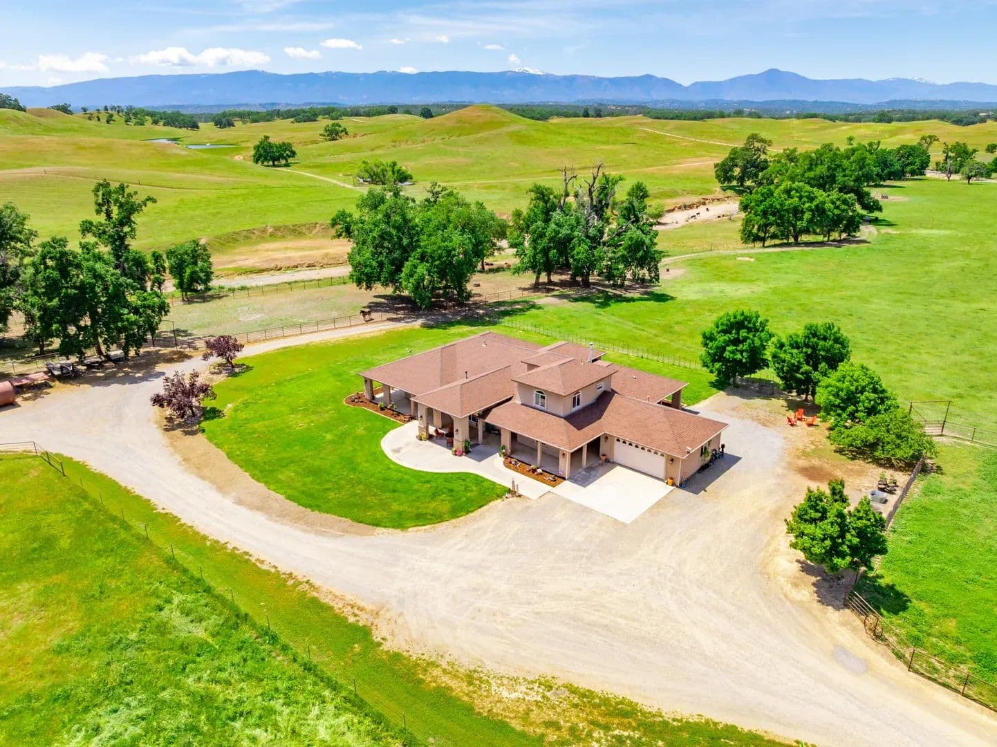
Red Bluff Ranch
$2,375,000
222.42 Acres
Red Bluff, California, 96080
The Red Bluff Ranch is a 222-acre turnkey property in Tehama County near Red Bluff. West of town, this cattle ranch includes a custom home, large barn, guest home, shop, creek, pond and more. The property has paved public road access, great water and striking vistas of the foothills and mountains. This stunning ranch is quiet, private and provides complete horse and livestock equipment. With scenic views and more this ranch awaits your company.Land This fertile property ranges from 620’ to 740’ with prime grazing land and a variety of trees. Reeds Creek traverses the ranch with a large +4.5-acre spring-fed year-around pond near the center of the property. There are two additional seasonal ponds providing even more water for livestock and wildlife. The land is sectioned off into multiple pastures and cattle traps/corrals with numerous water troughs throughout the ranch. Approaching the property from either direction along Johnson Road provides rich views of this highly desirable ranching area. The property is zoned AG-1, has great livestock carrying capacity and is enrolled in the Williamson Act. The land also provide rich habitat for area wildlife.APNs: 022-190-022-000 (26.99-ac), 025-010-018-000 (179.30-ac), 025-010-020-000 (13.49-ac), 025-010-091-000 (2.64-ac).Legal description, acreages, improvements, easements, property markers/monuments and other items to be verified by title and/or survey. Fences, if any, are “convenience fences” and do not indicate property boundaries. Maps are for illustrative purposes only and do not indicate or verify property boundaries or other improvements.Improvements MAIN HOME: Approx. 3000-sq. ft. newer home. The nicely appointed home includes spacious front and rear entry areas, complete kitchen with pantry storage, adjacent dining area, brightly lit great room, office/multipurpose room, laundry/storage, multiple first floor bedrooms and closets, first floor bathrooms, second floor bedroom and closet, additional loft area, and second floor bathroom. The home has many windows providing outstanding views to the ranch. A full wrap-around covered patio area provides generous shaded and weather-protected outdoor living areas. The home is fully landscaped with spacious entertaining areas. A septic system and propane tank serves the home and guest house.GARAGE: ~576-sq. ft. approx. 24’x24’ garage building with separate single garage door and laundry hook-ups. A large, covered patio connects the garage and the main home.GUEST HOME/SHOP: ~1,440-sq. ft. approx. 60’x24’ building with an ADU including complete kitchen, bar/counter area, front room, dining area, bedroom, bath and more. Building includes two large separate locked storage/shop rooms with exterior entrances and 220V power. A ~480-sq. ft. approx. 8’x60’ covered concrete porch area along the full length of the north side of the building provides shade and weather protection.MAIN BARN: ~7,000-sq. ft. multi-purpose wood-framed barn with ~200 sq. ft. vet room, ~200 sq. ft. tack room, seven (7) horse stall/pens, 110v power, water, power, lighting and more. This fully equipped barn includes four (4) large sliding/locking main access doors. The barn also includes mezzanine storage areas with external access doors.PUMPHOUSE WELL BUILDING: Wood building for water well pump and more. The well is ~300’ deep with a static level of ~95’. A new 7.5-hp pump was installed in 2016. The well previously supplied 650 GPM when it was used to irrigate multiple pastures.STORAGE CONTAINER: 8’w x 8’h x 20’ long steel container unit located on the east side of the guest home building.OTHER: The land is fenced and cross-fenced with 5-strand barbed wire and t-post fencing with internal ranch access, welded pipe gates and other features and equipment. The ranch includes multiple pens, corrals, loading chute and more. The main driveway off Johnson Road is also gated.Buildings, structures, square-footages and other details are approximate.Recreation The property is located in the upland foothills west of Red Bluff. The Trinity National Forest is to the northwest, Mendocino National Forest to the southwest, Shasta-Trinity National Forest to the north and the Lassen National Forest to the east. The region has many lakes, rivers, streams, foothills and mountains providing a wide range of outdoor recreation activities. The river valley cuts a rich, 20 mile wide swath through the Central portion of Tehama County, which provides endless varieties of outdoor recreation. The Sacramento River is one of the largest salmon spawning rivers in the world. Tehama County is the central point of widespread recreation and the local recreation opportunities are outstanding with nearby camping, hunting, fishing, golfing, snow skiing, and boating resources as good or better than anywhere in California. Camping opportunities throughout the County range from fully developed campgrounds to secluded sites. With more than 300-miles of trails, hiking within Tehama County can be a day-trip adventure or a week—long backcountry experience.Agriculture With its great water supply and fertile soil, the property is well suited for horse and cattle grazing with additional farm/ag opportunities. A large portion of the land is set up for irrigation.Water/Mineral Rights & Natural Resources Contact AgentRegion & Climate Red Bluff is home to the Red Bluff Round-Up, the largest three-day rodeo in the country, with a tough cowboy reputation. The event proudly hosted its 100th anniversary in 2021. The town is also home to The Red Bluff Bull and Gelding Sale which began in 1941 when a small group of local ranchers and a local farm advisor decided to start a Hereford show and sale in Red Bluff. What developed out of that Hereford show 80 years later is considered the greatest stock show and sale west of the Rockies. The sale has evolved into a western extravaganza, revered by consignors, buyers and attendees as the premier Bull and Gelding Sale; and a top destination for anyone in the ranching industry. Red Bluff is also home of the Tehama District Fairgrounds and Fair. Red Bluff and neighboring towns offer year-round residents and visitors varied climate and weather. Red Bluff has a Mediterranean climate with cool, wet winters and hot, dry summers. An average of 100 days annually have highs of 90°F or higher and an average of 21+ days with lows of 32 °F or lower.History RED BLUFF: In the early 19th century, the Siskiyou Trail was the main north-south path connecting Northern California and Southern Oregon first used by the Native Americans and later fur trappers and hunters. The first European to settle the northern Sacramento Valley in what was then Alta California was Peter Lassen, who in 1844 was granted the 24,000-acre Rancho Bosquejo tract from the Mexican government near present-day Vina, about 20 mi southeast of Red Bluff. There, he proposed to establish a town, but his attempts were thwarted when the California Gold Rush stole the focus of the settlers he had gathered in Missouri. Regardless, the publicity from his colonization efforts attracted new settlers to the valley. In the late 1840s, riverboat traffic began expanding northward along the Sacramento River. Lassen’s initial attempt to navigate to his ranch in 1849 had failed, but the following year, a riverboat managed to make the arduous 125-mile journey from Sacramento in 5 months before ultimately being sunk. The discovery of gold near Yreka, California, in 1851 brought a new rush northward and settlers soon flooded the area, looking for the quickest route to the gold fields. A site on the Sacramento River just north of Reeds Creek was determined to be the river’s navigable head, and a small community soon sprung up around the important landing. First known as Leodocia then Covertsburg, by the time a post office was established on October 17, 1853, residents had settled on the name Red Bluff, in recognition of the titular geographical features once prominent along the banks of the Sacramento River.TEHAMA COUNTY: Formed from parts of Butte, Colusa, and Shasta Counties in 1856. The first permanent non-indigenous settlers in the area that is now Tehama County were Robert Hasty Thomes, Albert Gallatin Toomes, William George Chard, and Job Francis Dye. The four men were each given land grants by the government of Mexico in 1844. Thomes received Rancho Saucos, Toomes received Rancho Rio de los Molinos, Chard received Rancho Las Flores, and Dye received Rancho Primer Cañon o Rio de Los Berrendos. Later in the same year Josiah Belden received Rancho Barranca Colorado. Famous early figures include Kit Carson, who took part in a fight that gave name to Bloody Island and Battle Creek, Jedediah Smith, John C. Fremont, and William B. Ide, the first and only president of the California Republic.Source: WikipediaLocation Red Bluff Ranch is approximately 13-miles to downtown Red Bluff. The County Seat, Red Bluff, is located on Interstate 5 and the Sacramento River approximately 135-miles north of Sacramento and 35-miles south of Redding. Nestled in the northern Sacramento Valley, Tehama County lies approximately midway between Sacramento and the Oregon border. Starting in the snowy Sierras to the east, the County unfolds onto rolling foothills, excellent range land, and spectacular, flat-topped buttes, and then sweeps down onto the fertile floor of the Sacramento River Valley.

Mt. Shasta Villa
$805,000
6.7 Acres
Mount Shasta, California, 96067
The Mt. Shasta Villa is a 6.70-acre property in Mt. Shasta in Historic Siskiyou County. Located 3-miles west of Mt. Shasta’s town center, this turnkey property includes a custom designed home, detached garage, and a second ADU, all with spectacular views. Nestled in a quiet neighborhood at the southwest flank of Mt. Shasta, this quiet retreat property is centrally located with great access to resources and endless recreational opportunities.Land The land ranges from 3,505’ to 3,640’ and is adjacent to the Siskiyou Land Trust on the north and west. The property has convenient, well-maintained paved access along Wyehka Way. The property is comprised of two contiguous parcels, both of which front Wyehka Way. The land is gently sloped and includes lush conifer and other tree cover. APNs: 036-110-030, 1.60-acres; 036-110-020, 5.10-acres; Total of 6.70-acres.Legal description, acreages, improvements, easements, property markers/monuments and other items to be verified by title and/or survey. Fences, if any, are “convenience fences” and do not indicate property boundaries. Maps are for illustrative purposes only and do not indicate or verify property boundaries or other improvements.Improvements MAIN HOME: Multi-level custom designed home with many special upgrades and built-ins. New hardwood flooring, paint and other improvements/upgrades. Foyer; expansive kitchen; dining area; great/family room; multiple full bathrooms; main bedroom with custom built-in bathroom with multiple sinks, shower, sunken tub, and more; transition room leading to separate hot tub room, utility/laundry/bathroom and bedroom; multipurpose loft room; second level bedroom and bathroom; numerous closets and storage areas. See floor plan images and attachments. Expansive views. Private, quiet and highly desirable area.ADU: Mobile home with bedroom, full bath, kitchen, dining area, living area and additional storage room annex. Includes covered wood deck entry area.Water well, septic system and propane tank serves both the main home and ADU. Covered and exposed irrigation ditch travesrves property.Recreation “When I first caught sight of Mount Shasta over the braided folds of the Sacramento Valley, my blood turned to wine, and I have not been weary since.” –John Muir, 1874The property is located in the Historic town of Mt. Shasta at the base of the majestic Mt. Shasta mountain, one of the most iconic and beautiful peaks in the U.S. With nearly 445,000 acres of awe-inspiring wilderness, Siskiyou county is an outdoor enthusiast’s dream with the ideal environment to hike, climb, fish, hunt, swim, bike, golf, explore caves and more. Castle Crags State Park is 14-miles south of town and the expansive and popular Shasta Lake is further south along Interstate-5. The area is surrounded by several national parks and refuges, including Tule Lake National Refuge to the northeast.Agriculture The property includes a robust variety of conifer timber and other trees.Water/Mineral Rights & Natural Resources Contact Listing AgentRegion & Climate Siskiyou County is located in inland northern California, adjacent to the Oregon border. As the fifth largest county in California by area, Siskiyou County features spectacular natural beauty and scenic cities and towns including Yreka–the County Seat, Mt. Shasta, Weed, Dunsmuir, McCloud and Tulelake as well as Butte Valley, Scott Valley, Shasta Valley and the Klamath River Corridor. Next to the Appalachian region, Siskiyou County is one of the most ecologically diverse regions in the world. It sites the meeting of several western mountain ranges and the transitional mixing of various habitat types.Mount Shasta to the east forces moisture out of the air as it rises and cools, and the dip in the Klamath Mountains allows more moisture to reach inland, so the city receives more precipitation than the semiarid region to the north. This means that in the winter, the city gets nearly 103 inches or 2.62 meters of snowfall despite its low 3,600 feet elevation. The Köppen climate classification is Csb, or warm-summer Mediterranean climate. The USDA hardiness zone is 7b.History For thousands of years, the Shasta, Klamath, Pit, Modoc, and Wintu tribes utilized the abundant natural resources of the Mount Shasta area. In the 1820s, Euro-American trappers and hunters followed the Siskiyou Trail—an ancient network of Native American footpaths connecting California and the Pacific Northwest—through the region. Silver and gold discoveries after 1851 attracted miners. The area was first known as Strawberry Valley, then Berryvale, with a post office opening in 1870. In 1886, the town was renamed Sisson after local businessman Justin Hinckley Sisson, who operated the Strawberry Valley Station stagecoach inn and donated land for the Central Pacific Railroad station. Completion of the railroad in 1887, along the Siskiyou Trail route, spurred tourism, logging, and population growth. Tourism and lumbering remained key industries into the 1900s, bolstered by a wave of Italian immigrants employed in timber. The city was incorporated on May 31, 1905, and officially named the “City of Mount Shasta” on November 10, 1925. According to the U.S. Census Bureau, Mount Shasta covers 3.8 square miles, nearly all land. A stream in the southern part of town flows into Big Springs Creek and then Cold Creek, feeding the South Fork of the Sacramento River. The town lies on the gently sloping southwest flanks of Mount Shasta, with surficial soils of Quaternary alluvium, underlain by volcanic deposits. Groundwater is shallow, with peat soil (about two feet thick) overlaying sand and gravel stream deposits.Location Mount Shasta is located at 41°18’52” North, 122°18’41” West, along Interstate-5; 10-miles south of Weed and 12-miles north of Dunsmuir. McCloud is 12-miles to the east along CA-89. Redding is about hours’ drive south and the Oregon border is 70-miles north. The property main address is 1901 Wyehka Way, Mt. Shasta, CA 96067.