Search Brokers - Kevin Branum
Kevin Branum
Route 66 Investment Opportunity
Kevin Branum is a land and rural real estate professional with Route 66 Investment Opportunity, listed on Land Broker MLS, the broker-owned co-op for farms, ranches and land for sale. Use the contact form on this page to get in touch about buying or selling rural property.
Contact
Fill in the Form below to send a message to this broker
By submitting, you agree to our privacy policy and terms.
Land for Sale from Kevin Branum

Cedarosa
$1,174,999
320 Acres
Bluewater, New Mexico, 87005
Experience the beauty of western New Mexico at this property, set in a unique location close to town, ideal for those seeking tranquility, natural splendor, and the distinctive charm of the Southwest. The spacious main home provides comfortable living with ample room, while an additional guest house offers flexible accommodations for visitors or extended family. Land The mesas are comprised of elevated plateaus with exposed rock outcroppings and sheer edges, providing dramatic topography and panoramic views of the surrounding terrain. These rocky formations are interspersed with native juniper, piñon pine, and scattered desert vegetation, typical of the region’s high desert ecosystem.Below the mesas, the land transitions into broad, gently sloping bottom grasslands. These areas are covered with native grasses such as blue grama, western wheatgrass, and galleta, offering valuable open space for grazing, wildlife habitat, or hay production. The soil in the grasslands is a mix of loamy and sandy textures, well-suited for supporting native vegetation and occasional agricultural uses.Improvements The southwestern style main home features a spacious open floor plan designed for comfortable living and entertaining. It includes four generous bedrooms and three and a half bathrooms, providing ample space for family and guests. Enjoy a large recreation room perfect for gatherings, hobbies, or relaxation, as well as an inviting outdoor entertaining area ideal for dining or socializing in moderate southwestern temperatures. Additional amenities include refrigerated air, a convenient two-car garage, and a surrounding block wall combining functionality with the charm of rural living.The guest house is a fully modernized old ranch home that blends historic character with contemporary comfort. It boasts an amazing kitchen designed for both everyday living and entertaining, complemented by a large spacious porch to extend gathering areas. The layout includes two well-appointed bathrooms and a large ensuite, offering privacy and luxury for residents and guests alike. This inviting space is perfect for extended family, visitors, or as a charming rental opportunity.The property includes a spacious shop featuring two large doors, making it ideal for any hobbyist or those needing ample workspace. Inside, there’s plenty of room for projects, vehicles, or equipment. Additionally, two storage containers provide convenient extra space for storing tools, seasonal items, or any extras you might have, ensuring everything stays organized and easily accessible.A newly painted red barn adds classic rustic charm to the property, creating a picturesque and inviting focal point. The barn offers generous space to comfortably accommodate horses or other four-legged friends, with practical features designed for animal care and management. Complementing the barn is a well-maintained set of corrals, making this property an excellent choice for equestrian enthusiasts or anyone seeking a functional and attractive setup for livestock.Recreation The property features its own private walking trails and thoughtfully placed benches, providing a perfect setting for daily outdoor activities and relaxation. Enjoy peaceful strolls, nature watching, or simply unwind while taking in the scenic views—all within the comfort and privacy of your own land.Cibola county, NM offers a wide range of outdoor recreation opportunities for nature lovers and adventure seekers. Nestled near the scenic Cibola National Forest and surrounded by mesas, lava flows, and red rock formations, Grants is a gateway to hiking, biking, and horseback riding on miles of picturesque trails. The area is renowned for El Malpais National Monument, where visitors can explore stunning volcanic landscapes, sandstone bluffs, and unique caves.Nearby Bluewater Lake State Park offers excellent fishing, boating, and camping, while the surrounding wilderness provides ample opportunities for wildlife viewing and birdwatching. Off-road enthusiasts can enjoy ATV and dirt bike trails, and the open skies make this region ideal for stargazing. Whether you’re interested in exploring ancient lava tubes, climbing rugged terrain, or simply soaking in breathtaking sunsets, this region delivers outstanding outdoor recreation experiences year-roundAgriculture Western New Mexico offers a favorable environment for a variety of agriculture and homesteading pursuits, making it an excellent choice for those seeking a self-sufficient or rural lifestyle.General Operations Homesteading Possibilities:The 320-acre property offers expansive space for a rural lifestyle, with room for gardens, orchards, and livestock. Existing infrastructure includes a barn, shop, and corrals to support a range of potential uses. The land and improvements may be suitable for agricultural or homestead-style activities, subject to applicable local guidelines.Nature-Based Business Opportunities:The expansive acreage offers a scenic setting that may lend itself to a variety of nature-oriented uses. Potential opportunities could include a wellness or retreat setting, guided nature walks, birdwatching or photography experiences, horseback riding activities, or a small-scale glamping concept. The rolling terrain, red rock bluffs, and native grasses provide a picturesque backdrop for outdoor gatherings and recreational pursuits, depending on buyer vision and applicable local guidelines.Region & Climate Grants, New Mexico, enjoys a semi-arid climate characterized by mild winters, warm summers, and low humidity. The area boasts an impressive average of over 270 days of sunshine each year, making it ideal for those who appreciate bright, clear skies. Summer daytime temperatures typically range from the mid-80s to low 90s °F, while nights are cooler thanks to the region’s elevation of about 6,500 feet. Winters are generally mild, with daytime highs in the 40s and 50s °F and occasional light snowfall. The area receives relatively low annual precipitation, most of which falls during the summer monsoon season. Overall, Grants offers a pleasant climate with abundant sunshine, perfect for outdoor activities almost year-round.History The region is known for its natural attractions, including El Malpais and El Morro National Monuments, and has a history deeply connected to mining, agriculture, and the railroad. Today, Cibola County is celebrated for its scenic beauty, outdoor recreation, and cultural diversity.Location Grants offers a welcoming small-town atmosphere with essential amenities for comfortable living. Residents and visitors enjoy a variety of local restaurants, cafes, and grocery stores, as well as medical facilities, pharmacies, and retail shops. The town features public parks, fitness centers, golf courses, and recreational facilities, creating opportunities for leisure and community events. Grants is also home to schools, libraries, and a hospital, ensuring convenient access to education and healthcare.Located about 80 miles east of Grants, Albuquerque is New Mexico’s largest city and provides a full spectrum of urban amenities. Residents and visitors have access to major shopping centers, diverse dining options, vibrant arts and cultural attractions, museums, theaters, and entertainment venues. The city boasts specialty medical facilities, universities, and research centers.Albuquerque International Sunport (ABQ) is the primary airport serving the region. Conveniently located in Albuquerque, the Sunport offers direct flights to major cities across the United States, as well as select international destinations. The airport features car rental services, ground transportation options, and modern passenger amenities, providing efficient and accessible air travel for both business and leisure. Its proximity to Grants makes national and international travel convenient and straightforward.

Lot 12 Cantina Acres
$50,000
5.09 Acres
Grants, New Mexico, 87020
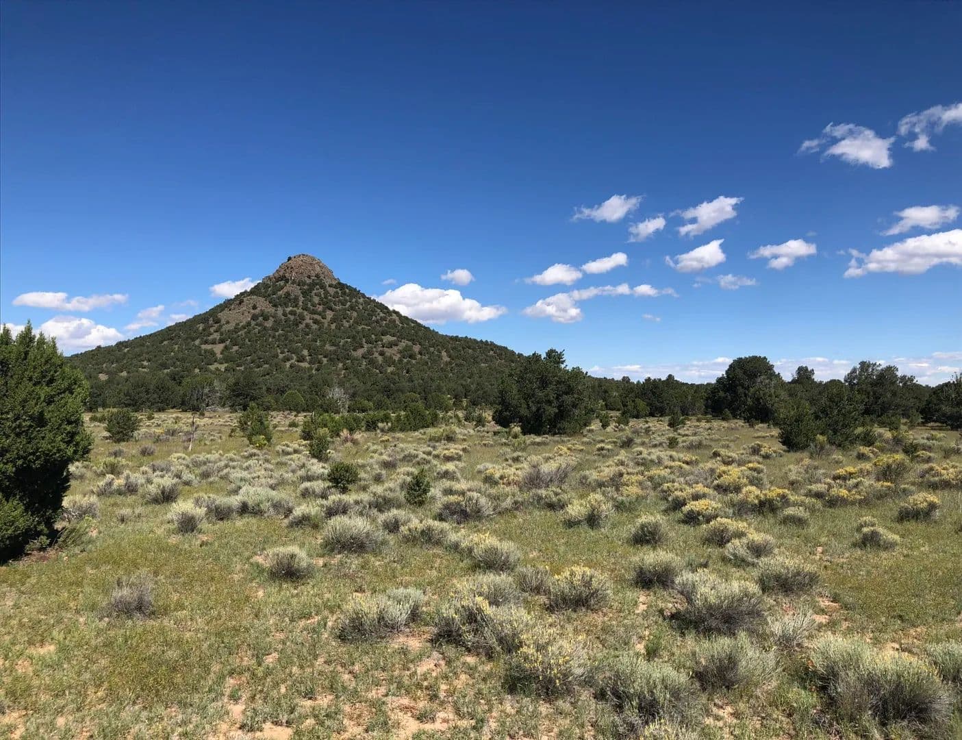
This property is truly one-of-a-kind, offering a stunning combination of natural beauty and ease of access. Spectacular 360° panoramic views from every angle, allowing you to experience breathtaking scenery all year round. Just a few minutes from town is a rare opportunity to build your dream home.Land Rolling hills along the edge of La Jara mesa where there is an abundance of wildlife and vegetation including blue grama grasses, juniper and cholla.Recreation Mount Taylor in New Mexico is a renowned destination for outdoor recreation enthusiasts, offering a wide range of activities throughout the year:Hiking & Backpacking: Explore scenic trails like the Gooseberry Springs Trail and the La Mosca Lookout, with routes suitable for all skill levels. Enjoy breathtaking vistas, wildflowers, and unique geological formations.Mountain Biking: The area features challenging and rewarding mountain biking trails, including portions of the Continental Divide Trail, providing adventure for both beginners and experienced riders.Camping & Picnicking: Several campgrounds and picnic areas are located on and around Mount Taylor, making it perfect for weekend getaways and family outings.Wildlife Watching: Spot elk, deer, eagles, and other wildlife in their natural habitats. The diverse ecosystems around the mountain make it a haven for birdwatchers and nature lovers.Winter Sports: In the colder months, enjoy cross-country skiing, snowshoeing, and winter hiking along the mountain’s snow-dusted trails.Cultural Exploration: Mount Taylor is a sacred site for several Native American tribes. Visitors can learn about its cultural significance and the history of the region.Region & Climate Grants, New Mexico, enjoys a high desert climate characterized by four distinct seasons and abundant sunshine throughout the year.Summers: Warm and dry, with daytime highs typically in the 80s to low 90s °F (27–34°C). Nights are cooler, dropping into the 50s and 60s °F (10–20°C), making evenings comfortable.Winters: Cool to cold, with daytime highs in the 40s to 50s °F (4–15°C), and nighttime lows often dipping below freezing. Snowfall is light but possible, especially due to the town’s elevation.Spring & Fall: These transitional seasons bring mild temperatures and are often considered the most pleasant times of year, with crisp mornings and warm, sunny afternoons.Location The distance from Cantina Acres in Grants, NM to Albuquerque International Sunport (Albuquerque airport) is approximately 80–85. The drive typically takes around 1 hour and 15 minutes via Interstate 40 East

Black Mountain Retreat
$739,000
80 Acres
Pie Town, New Mexico, 87827
Welcome to this unique property just outside of Pie Town, NM, a hidden gem that has served as both an outfitter operation and a tranquil retreat. Nestled amidst the stunning New Mexico landscape, this expansive estate offers a rare blend of rustic charm and modern comfort, making it an ideal investment opportunity or a personal sanctuary. A main lodge with many sleeping quarters and a commercial kitchen make this property turnkey for anything.Land Approximately 80 acres adjacent to public lands. These lots have some heavy stands of ancient piñon and juniper trees, with open fieldsof blue grama grass, perfect for horses. The topography is also diverse, with shale ridges, high viewpoints, and secluded low areas. Sensible covenants are in effect. A community well and electric service are available, and telephone and DSL broadband Internet service are installed to every lot line.The surrounding area offers excellent hunting, fishing, hiking and cattle ranching. There are also historic Indian ruins, cliff dwellings, and national forests nearby, and Continental Divide Trail is adjacent to the development. Serene meadows, streams and lakes provide unlimited recreational opportunities and habitat for the local wildlife,which includes deer, antelope, bear, elk, bobcat, and wild turkey.Improvements Main lodge (constructed of steel) 2000 sq ft (40×50) with 16 ft ceilings with partialsecond story (494 additional sq ft). This buildingis comprised of 390 sq ft of kitchen/dining area, 260 sq ft second storybedroom, 234 sq ft second story loft/office, 1,320 sq ft great room, 113 sq ft bathroom, with a 400 sq ft covered front porch area. Just behind the main lodge is a 12×12 storage building.There are four sleeping cabins (12×24 each divided into 2 rooms) each room is 131 sq ft. Each room has onebunk bed and one full bed. There are 8 rooms total between all four cabins.There is a 12×24 bathroom house with four full bathrooms. Each bathroom is 65 sq ft and eachhas a stand up showerThere is an onsite laundry facility that is 10×11 – 110 sq ft laundry room with 3 washers and 3 dryers.The 40×85 barn has a loft and storage. It is 2 stories and 40x 50 of it is enclosed. Building has a 300sq ft bunk room with 6 beds, 8 individual rooms 60 sq ft each with 1 bed each, 183 sq ftloft with 6 beds, horse stall of 136 sq ft, 136 sq ft wet room/kitchen/dry storage, 190 sqft game cleaning room enclosed, and 288 sq ft covered outdoor game cleaning area.12 RV hookups each with their own 30 amp service1 fully functional well with 1500 gallons of water storage.10×10 covered gazebo for shooting rangeRecreation Experience the unparalleled outdoor recreation opportunities in Pie Town, NM, a haven for nature lovers and adventure enthusiasts alike. Nestled in the captivating landscapes of the high desert, this area boasts a diverse array of activities that cater to all interests and skill levels.Hiking and Biking: Explore miles of scenic trails that wind through dramatic canyons, rolling hills, and open meadows. The terrain offers both leisurely walks and challenging hikes, providing breathtaking views of the surrounding mountains and the vibrant New Mexico sunset. Mountain biking enthusiasts can also enjoy trails that vary in difficulty, making it an ideal destination for exploring on two wheels.Fishing: The nearby waters are teeming with trout, making Pie Town a prime spot for anglers. Whether you prefer tranquil streams or larger lakes, you’ll find the perfect location to cast your line and enjoy a day of fishing while surrounded by serene natural beauty.Wildlife Viewing: Pie Town is home to an abundance of wildlife. Bird watchers can delight in spotting many species, while those with a keen eye might catch glimpses of deer, elk, and other local fauna. The area’s diverse ecosystems create a thriving habitat for various creatures, making every outdoor adventure an opportunity for discovery.Stargazing: Known for its clear night skies and minimal light pollution, Pie Town is a stargazer’s paradise. Lay back and marvel at the celestial wonders, from the Milky Way to shooting stars, as you immerse yourself in the tranquility of the night.Horseback Riding: Experience the rugged terrain on horseback, with options for guided rides or the chance to bring your own horse. There are plenty of trails and open spaces that provide a unique perspective of the stunning landscapes.Whether you’re seeking adrenaline-pumping activities or peaceful retreats into nature, Pie Town, NM, offers something for everyone. Embrace the great outdoors and create unforgettable memories in this beautiful part of New Mexico.General Operations Historically this property has been used as a rental property for family retreats and gatherings as well as an outfitter operation.Region & Climate Piedra (often referred to as Pie Town) in New Mexico has a high desert climate characterized by four distinct seasons. Summers are typically warm, with daytime temperatures averaging in the mid-80s to low 90s Fahrenheit (about 29-34°C), but can occasionally rise higher. Nights tend to cool down significantly, often dropping into the 50s Fahrenheit (around 10-15°C). Winters can be quite chilly, with daytime temperatures generally ranging from the upper 30s to low 50s Fahrenheit (around 3-12°C). Nighttime temperatures can dip below freezing. Snowfall is possible but tends to be light and infrequent. Spring and fall are transitional seasons, featuring mild temperatures and a mix of sunny and partly cloudy days. Rainfall is relatively low throughout the year, with most precipitation occurring during the summer months, often in the form of brief thunderstorms. Overall, Pie Town’s climate offers a mix of warm summers, cool winters, and picturesque seasonal changes.History Pie Town, New Mexico, has a unique and rich history that dates back to the early 20th century. It was established in the 1920s as a small community primarily populated by homesteaders who were attracted to the region’s vast open landscapes and opportunities for farming and ranching. The town’s name is famously linked to its pie-making traditions. In the 1920s, a local woman named “Minnie” and others began selling homemade pies to travelers and the growing population. This culinary focus helped define the town’s identity, and it became known as a destination for delicious pie, leading to the charming name “Pie Town.” During the Great Depression, Pie Town served as a home to many families who moved westward in search of better opportunities. The town gained further recognition in the 1930s when it was featured in various national publications, highlighting its unique character and resilience. In the following decades, Pie Town remained a small, tight-knit community, with a focus on agriculture and a simple rural lifestyle. The town also became a stop along Route 66, further adding to its appeal and commerce. Today, Pie Town is known for its friendly atmosphere, pie shops, and annual events like the Pie Town Pie Festival. The town’s history is celebrated by its residents who cherish the traditions that have shaped their community over the years.Location Grants-Milan Municipal Airport (GNT): Located about 50 miles (approximately 80 kilometers) to the north of Pie Town, this airport offers limited commercial flights and is primarily used for general aviation.For more extensive flight options, travelers might consider flying into larger airports such as **Albuquerque International Sunport (ABQ)**, which is about 130 miles (around 209 kilometers) northeast of Pie Town. This airport offers a wide range of domestic and some international flights.While Pie Town is not directly served by major airports, these nearby options facilitate access to the community for visitors.

Shadow Canyon’s Elk Paradise
$820,000
100 Acres
Fence Lake, New Mexico, 87315
Experience the ultimate turnkey (several pieces of equipment include) hunting retreat—ready for you to enjoy from day one! This exceptional property features a custom-built home, an oversized two-car garage, and multiple outbuildings designed to make preparing your harvest effortless. Established food plots and a strategically placed hunting blind are already in place, so you can start hunting immediately. Land This roughly 100-acre parcel has a variety of topography. There are open feeding areas as well as dense pockets of trees making the perfect bedding areas for elk and deer. The pond that fills from runoff is 75 yards from the front door and attracts a lot of different widlife. The 4 lots also include varying elevations giving you some ideal vantage places to either listen for the bugles in September or glass up the wildlife the rest of the year.Improvements Custom-built 3-bedroom, 2-bath main home with log siding, tongue and groove, and painted concrete floors with extra-wide porches around all 4 sides, complete with an outside bar area on the north end. It has been very well maintained and has a backup generator as a bonus. Right behind the house is a gazebo with a hot tub and a sitting area. As you come up to the end of the driveway and a short walk across to the house, you will find an oversized 2 car insulated garage that has a half bath (could easily be 3/4 as drain and plumbing are still in place) with work benches, a wood burning stove, and a 3 bay sink with all the amenities to process your own game. Right adjacent to the garage is an RV-height carport with water and electrical hookups. There are also two standard-size carports, separated by a 20′ container, to hold additional tools, supplies, and yard equipment. In addition to all of this, there is a metal-frame and siding barn. It has electricity and water, and a game hoist is already installed to make processing that game even easier. This barn could easily be used for livestock, with some adjacent panels forming corrals. All the buildings have been well-kept and are very functional.List of equipment includes: tractor with many implements, hot tub, seed drill, 2 seat UTV, large bbq grill, portable generator, riding lawn mower, push lawn mower, chain saws, wood splitter, leaf blowers and weed eaters. Theres also tool boxes with miscellaneous tools and parts.Recreation Fence Lake, New Mexico, offers a peaceful rural setting surrounded by the natural beauty of the high desert and wide-open skies. Outdoor recreation in the area centers around activities such as hiking, horseback riding, and wildlife watching, with plenty of opportunities to explore the rolling grasslands and scenic mesas nearby. The region’s quiet roads are ideal for cycling and leisurely drives, while stargazing is exceptional thanks to minimal light pollution. Though there are no major lakes or rivers for water sports, the vast landscape provides a perfect backdrop for camping, photography, and enjoying the solitude and tranquility of the New Mexico countryside. The nearby Cibola National Forest and El Malpais National Monument are within driving distance, offering additional opportunities for adventure and exploration.Region & Climate Fence Lake, NM experiences a semi-arid climate, characterized by warm summers, cool winters, and low annual precipitation. Summer daytime temperatures often reach the mid-80s to low 90s°F (high 20s to low 30s°C), while nights cool off significantly. Winters are generally mild, with daytime highs in the 40s and 50s°F (5–15°C) and occasional freezing nighttime lows. Rainfall is sparse, with most precipitation occurring during the summer monsoon season, and snowfall in winter is typically light. The area enjoys abundant sunshine year-round and low humidity, making for clear skies and comfortable outdoor conditions most of the year.History Fence Lake, New Mexico, is a small rural community with roots dating back to the early 20th century. The area’s name comes from a nearby seasonal lake that was once surrounded by a wire fence to contain livestock, a nod to the region’s ranching heritage. Fence Lake developed as a ranching and farming settlement, serving as a home for homesteaders and families drawn by open land and the promise of agricultural opportunity. Though the population has always remained small, the community has maintained its rural character and continues to reflect the traditions of ranching, farming, and close-knit country living that shaped its early days.Location Fence Lake, NM is a remote rural community, so the closest airports are located a considerable distance away. Here are the approximate distances to the nearest major airports:Gallup Municipal Airport (GUP): about 70 miles northwestAlbuquerque International Sunport (ABQ): about 155 miles eastGrants-Milan Municipal Airport (GNT): about 85 miles northShow Low Regional Airport, AZ (SOW): about 110 miles west
Mujeres 45 Hunting Camp
$112,500
45 Acres
Fence Lake, New Mexico, 87315
Escape to your own 45-acre retreat! This vacant land features rolling slopes, striking rock outcroppings, and a beautiful mix of pinon pine and juniper trees. Wildlife is abundant, making it an ideal spot for a weekend getaway or a base camp for hunting. With some inputs it could possibly qualify for an E Plus elk tag (not guaranteed and must be applied for) this property is perfect for outdoor adventurers seeking privacy and natural beauty.Land This property has a combination of dense tree areas as well as some open areas on the north side of the property. Grasses consist mainly of blue grama. Trees are a combination of pinon pine and junipers. There are some very large trees on the property. It has a couple of high knolls that seem to be covered in wildlife sign.Recreation The area around Quemado, NM offers a variety of outdoor recreational opportunities thanks to its scenic landscapes, public lands, and mild climate. Popular activities include:Hunting: The region is well-known for big game hunting, especially elk, deer, and turkey, with access to public and private lands.Fishing: Quemado Lake, about 20 miles south, is stocked with trout and offers boating, kayaking, and lakeside camping.Hiking & Camping: The nearby Gila National Forest and Apache-Sitgreaves National Forest provide miles of trails and campgrounds.Wildlife Viewing: The diverse forests and grasslands are home to elk, deer, birds, and other wildlife—perfect for photography and birdwatching.Horseback Riding & ATV: Many area trails and backroads are open for horseback riding and off-road adventures.Stargazing: With minimal light pollution, the area is excellent for night sky viewing.Sightseeing: Don’t miss the Lightning Field art installation, El Malpais National Monument (lava flows, caves), and the historic Very Large Array radio telescope nearby.Quemado’s quiet surroundings make it a great base for outdoor adventure and exploration.Region & Climate Summers: Warm days, usually in the mid-70s to upper 80s °F (24–31°C), with cool nights in the 40s and 50s °F (5–15°C). Thunderstorms are common in July and August during the “monsoon” season.Winters: Cold, with daytime highs often in the 40s °F (4–9°C) and nighttime lows frequently below freezing, sometimes dipping into the teens °F (-6 to -10°C). Snowfall occurs but is generally light to moderate.Precipitation: Annual precipitation averages 12–14 inches (300–360 mm), most of it falling from July to September.Humidity: Generally low, making the air feel crisp and dry.Sunshine: Abundant sunshine year-round.History Quemado, New Mexico, is a small rural community in Catron County. Its name means “burned” in Spanish, likely referencing historic fires in the area. The region was originally inhabited by Native Americans, including the Apache. Settlement by ranchers and homesteaders began in the late 1800s, and a post office was established in 1902. Quemado remains a quiet ranching community today, known for its scenic landscapes, abundant wildlife, and proximity to outdoor attractions like the Gila National Forest, Quemado lake and many other outdoor activities.
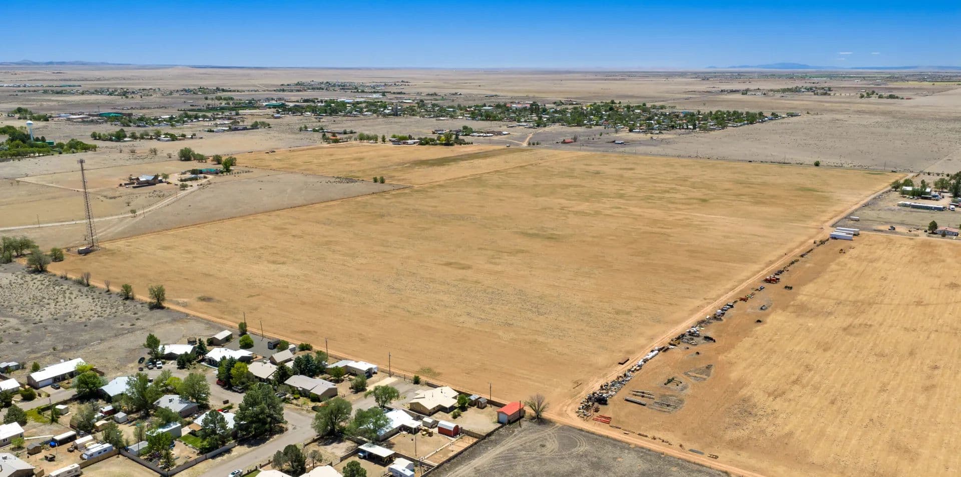
Future Forward: 80 Acres of Potential Development Property
$600,000
80 Acres
Moriarty, New Mexico, 87035
Huge price reduction and motivated seller! Adjacent to City Limits in Moriarty, NM. Discover a remarkable 80-acre, with 69.6 acre feet of water rights. This expansive land offers incredible potential for residential or commercial development, thanks to its prime location and paved access on the south side. Parcel is in opportunity zone for assistance programs.Land Land has been used in production agriculture. It is adjacent to Moriarty city limits and is believed to be able to be annexed into the city limits.It currently has a cell tower on the NE corner which could be leased for income. New well producing 70 GPM just completed in March of 2025.Land is flat and open creating many different development opportunities for homes, green energy or other commercial ventures with easy access to I-40 interstate.Recreation Moriarty’s location allows for day trips to nearby recreational areas such as the Sandia Mountains and other state parks for hiking, skiing, and more outdoor adventures. Whether you’re looking for a fun day out with the family or adventures in the great outdoors, Moriarty has something to offer for everyone!Agriculture Moriarty, NM, is situated in a region with a rich agricultural heritage, characterized by its diverse farming practices and fertile land. The area is well-suited for growing a variety of crops, including hay, alfalfa, and various grains. The favorable climate and irrigation from local water sources contribute to healthy crop yields. Moriarty’s surrounding areas are home to ranchers who raise livestock, including cattle, sheep, and goats. The open pastures provide excellent grazing opportunities, supporting both commercial and hobbyist farming.Water/Mineral Rights & Natural Resources Water rights are associated with this property making it perfect for either a housing development or an industrial/green energy parcel.Region & Climate Moriarty, NM, experiences a high desert climate characterized by distinct seasons and a range of weather conditions. Summers in Moriarty are typically warm to hot, with daytime highs often reaching the 80s to low 90s°F (around 27-37°C). Nights can be cooler, with temperatures dropping into the 50s°F (around 10-15°C). Winters are cold, with daytime highs ranging from the 30s to 50s°F (about 1-15°C) and nighttime lows that can dip below freezing.Moriarty receives relatively low annual precipitation, averaging around 12-15 inches (30-38 cm) per year. Most of the rainfall occurs during the late spring and summer months, often in the form of brief thunderstorms.The area enjoys abundant sunshine throughout the year, with many clear days, which is great for outdoor activities and agriculture.Overall, Moriarty’s climate is conducive to a variety of outdoor activities and agricultural practices, making it a pleasant place to live and work throughout the year.History Moriarty, NM, has a rich history that reflects the cultural and economic developments of the region. Moriarty was established in the late 19th century, around the time the railroad was expanding into the area. The town was named after the prominent local figure, John Moriarty, who played a crucial role in its development. The arrival of the Atchison, Topeka and Santa Fe Railway in the 1880s was pivotal for Moriarty. The railroad facilitated transportation and trade, turning the small settlement into a vital shipping point for agricultural products from the surrounding rural areas. Throughout the early to mid-20th century, Moriarty continued to grow as a hub for agriculture and commerce. The town developed essential infrastructure, including schools, shops, and services, supporting its expanding population. Today, Moriarty serves as a gateway to the East Mountain region while maintaining its identity as a rural community. The town continues to host various events that celebrate its history and agricultural roots, keeping the community spirit alive.Location The distance from Moriarty, NM, to Albuquerque International Sunport (ABQ) is approximately 30 miles (48 kilometers) when traveling via Interstate 40. The drive typically takes around 30 to 40 minutes, depending on traffic conditions. This close proximity makes Moriarty a convenient location for those who want to enjoy a quieter rural lifestyle while still having easy access to the amenities and services offered by Albuquerque.